



GPS RTK STEC SDi
Adopting a large signal-receiving sensor and distance measuring technology heritaged from total station, SDi can get the coordinates on the point where you shoot the laser, with an accuracy of less than 2cm within 5m and 3cm within 10m
t’s always been a headache when we intend to measure a remote point which is hard to reach, such as points across a river or road with running cars, or points inside the fence or under the building where satellite signal is not optimistic.
LaserFix on SDi is born to solve these difficulties.

A survey-grade EDM unit, powered by Automatic Gain Control, can adapts different intensity of light and guarantees a reliable measurement up to 70m.

Assisted by an advanced IMU and unique algorithm, SDi can collect the coordinates where the laser shoots with an accuracy of 2cm in 5m.

Stake out a remote point with laser is one of a kind application that SDi is capable of.

Slope distance, as well as other information such as reflection intensity and working status, are shown and refreshed in real-time.
70m
Maximum Range
2cm
Accuracy at 5m

Brosure
Hanya pelanggan yang sudah login dan telah membeli produk ini yang dapat memberikan ulasan.
Produk Terkait
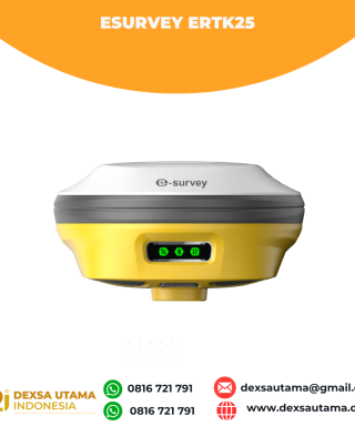

eSurvey eRTK25
Baca selengkapnyaLaser + CAD AR Dual-Tech Integration AR Stakeout: Overlay CAD designs onto real-world environments via AR, boosting on-site efficiency by 40%. Laser Precision: Achieve centimeter-level accuracy with non-contact measurements, ideal for extreme temperatures or tight spaces. High performance and stability: The eSurvey eRTK25 integrates laser ranging technology and AR vision stakeout, enabling robust centimeter-level positioning …

GPS GNSS Alpha Geo Matrix II AR + Laser
Baca selengkapnyaGNSS Alpha GEO Matrix II AR + Smart Laser Teknologi Canggih untuk Pengukuran yang Lebih Akurat dan Efisien AR – Stakeout Jadi Lebih Mudah dan Akurat GNSS Alpha Geo Matrix II Dengan fitur Augmented Reality (AR), Matrix II memungkinkan surveyor menandai titik langsung di lapangan tanpa perlu menggeser pole berulang kali. Cukup ikuti arah panah …

ESurvey E800
Baca selengkapnyaHigh-performance RTK Receiver
The E800 is a high-performance GNSS receiver that provides an easy-to-use solution for survey professionals who need to collect highly accurate data in a wide range of applications. The durable IP67 design makes it possible to work in extreme environments. The colorful touchscreen is convenient for quick configurations.

 0816 721 791
 dexsautama@gmail.com







Ulasan
Belum ada ulasan.