Kategori: LiDAR Laser Scanner
Menampilkan semua 9 hasilDiurutkan menurut yang terbaru
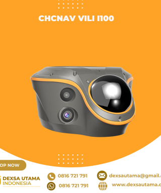

CHCNAV ViLi i100
Baca selengkapnyaThe ViLi i100 is CHCNAV’s flagship GNSS RTK receiver, combining advanced satellite filtering, enhanced SFix 2.0 positioning and innovative Vi-LiDAR technology. It provides reliable, centimetre-level accuracy even in challenging GNSS environments, allowing professionals to extend the boundaries of traditional GNSS surveying.

SatLab SL9 SLAM RTK
Baca selengkapnyaSatLab SL9 SLAM RTK combines high-precision GNSS positioning with cutting-edge SLAM technology, eliminating the spatial constraints of traditional RTK measurements. Whether in urban buildings, dense forests, or indoor environments, SL9 ensures reliable, precise measurements, redefining efficiency and versatility in fieldwork

Hitarget V700S SLAM RTK
Baca selengkapnyaHi-Target V700S SLAM RTK adalahperangkat GPS Geodetik inovatif yang menggabungkan teknologi Real-Time Kinematic (RTK) dan Simultaneous Localization and Mapping (SLAM). Perpaduan ini memungkinkan pengukuran dengan akurasi tingkat sentimeter, baik di area terbuka dengan sinyal GNSS kuat maupun di lokasi yang sulit dijangkau, seperti terowongan, lorong, atau di bawah jembatan

Laser Scanner Lixel L2
Baca selengkapnyaHandheld Real-Time 3D Reconstruction Laser Scanner Lixel L2: Teknologi Canggih untuk Scanner 3D Dalam dunia survei dan konstruksi, teknologi pemindaian 3D semakin berkembang pesat. Salah satu inovasi terbaru yang menarik perhatian adalah Laser Scanner Lixel L2, sebuah handheld real-time 3D reconstruction laser scanner yang mampu memberikan hasil pemindaian akurat dengan detail luar biasa. Apa saja …

Laser Scanner Lixel K1
Baca selengkapnyaLaser Scanner Lixel K1 – Scanner 3D Genggam yang Ringkas & Presisi Lixel K1 adalah perangkat pemindaian dan pemodelan 3D Lidar genggam yang ringkas, ringan, dan mudah digunakan. Dengan berat hanya 1 kg, alat ini dirancang untuk kemudahan mobilitas dan efisiensi kerja. Fitur Unggulan Laser Scanner Lixel K1 Ringkas & Mudah Dibawa – Material aluminium …

LiDAR CHCNAV AlphaAir 15
Baca selengkapnyaThe AlphaAir 15 (AA15) is a lightweight, high-performance airborne LiDAR system designed for large-scale operations where high-density data capture is crucial. With a range of up to 1800 meters and the ability to produce 2 million pulses per second, the AA15 is ideal for mapping and geospatial applications, including corridor mapping, urban planning, and vegetation analysis. Its compact design allows for easy integration with UAVs, small aircraft, and helicopters.

LiDAR CHCNAV AlphaAir 10
Baca selengkapnyaThe AlphaAir 10 is a professional airborne LiDAR+RGB system designed to meet the demanding requirements of UAV LiDAR mapping and drone photogrammetry. This advanced solution integrates superior LiDAR technology with accurate GNSS positioning, IMU orientation, and a professional full frame orthophoto camera. Together with CHCNAV’s point cloud and image fusion modeling software, the AA10 delivers survey-grade accuracy, efficiency, and cost-effectiveness in 3D data acquisition and processing

LiDAR CHCNAV AlphaAir 450
Baca selengkapnyaThe AlphaAir 450 is designed for simplicity and precision, making advanced geospatial reality capture accessible to non-professional users and those new to the technology. At an affordable price, the AA450 combines ease-of-use with high-precision capabilities. This lightweight, durable solution integrates a high-performance laser scanner, a professional-grade 26 MP industrial camera, and a high-precision inertial navigation system to ensure superior data collection quality.

Laser Scanner CHCNAV RS10
Baca selengkapnyaThe RS10 integrates GNSS RTK, laser scanning, and visual SLAM technologies into one single platform. This fusion increases the efficiency and accuracy of both indoor and outdoor 3D scanning and surveying tasks. It gives surveyors the ability to work in areas with weak GNSS signals, providing unparalleled flexibility. Designed for surveying, BIM, forestry, power line inspection, underground mapping, and more, the RS10 embodies versatility, making it an essential tool for professionals looking to expand their surveying capabilities.