



GPS Hitarget vRTK
adalah perangkat GNSS geodetik yang menggunakan metode Real-Time Kinematic (RTK) untuk memberikan akurasi posisi tinggi hingga tingkat sentimeter. Salah satu fitur utama yang membedakannya adalah penggunaan teknologi pemosisian visual dengan kamera ganda, yang memungkinkan pengukuran objek tanpa kontak fisik
Non-contact measurement greatly improves the usable range of GNSS and efficient safe operation.
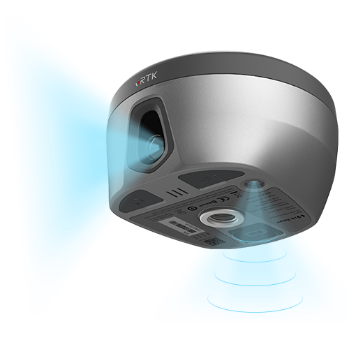
Spesifikasi
- Satellite Signals Tracked Simultaneously
- Channels: 1760
- GPS: L1CA / L1C / L2P(Y) / L2C / L5
- BDS: B1l / B2l / B3l / B1C / B2a / B2b*
- GLONASS: L1/L2/L3
- Galileo: E1 / E5a / E5 / AltBOC / E5b / E6
- SBAS: L1C/A, L5(QZSS, WAAS, MSAS, GAGAN)
- QZSS: L1 / L2 / L5 / L6*
- IRNSS: L5
POSITIONING PERFORMANCE
- High Precision static
- Horizontal : 2.5mm + 0.1ppm RMS
- Vertical: 3.5mm + 0.4ppm RMS
- Static and Fast Static
- Horizontal: 2.5mm + 0.1ppm RMS
- Vertical: 3.5mm + 0.4ppm RMS
- Post Processing Kinematic (PPK / Stop & Go)
- Horizontal: 8mm + 1ppm RMS
- Vertical: 15mm + 1ppm RMS
- Initialization time: Typically 10 min for base and 5 min for rover
- Initialization reliability: Typically > 99.9%
- Code Differential GNSS Positioning
- Horizontal: ±0.25m + 1ppm RMS
- Vertical: ±0.5m + 1 ppm RMS
- SBAS: 0.5m
Real Time Kinematic (RTK)
- Single Baseline
- Horizontal: 8mm+1ppm RMS
- Vertical: 15mm+1ppm RMS
- Network RTK(VRS, FKP, MAC)
- Horizontal: 8mm+0.5ppm RMS
- Vertical: 15mm +0.5ppm RMS
- Initialization Time: Typically 2-10s
- Initialization Reliability: Typically > 99.99%
- Provides RTK measurement even during differential signal interruptions
- Hi-Fix
- Horizontal: RTK+10mm / minute RMS
- Vertical: RTK+20mm / minute RMS
- Time to first Fix
- Cold Start: <45 s
- Hot Start: < 30 s
- Signal re-acquisition: < 2 s
- Image Accuracy
- Stakeout: Typically 2cm
- Image measurement: 2cm~4cm
- Tilt Survey Performance
- Additional horizontal pole-tilt uncertainty typically less than 8mm+0.7mm/°tilt(2.5cm accuracy in the inclination of 60°)
HARDWARE
- Physical
- Dimensions (W x H): 130mm x 79mm
- Wieght: lighter than 0.97kg (2.14lb) within internal battery
- Operation temperature: -40°C~+75°C (-40°F~+167°F)
- Storage temperature: -55°C~+85°C (-67°F~+185°F)
- Temperature Control: Auto-adjust the working power to maintain the temperature
- Humidity: 100% non-condensing
- Water/dustproof: IP68, protected from temporary immersion to depth of 1.0m (3.28ft)
- Shock and vibration: MIL-STD-810G, 514.6
- Anti-salt spray: MIL-STD-810G, 509.4, 96h
- Free fall: MIL-STD-810G, 516.6, designed to survive a 2m(6.56ft) natural fall onto concrete
- Charging
- Charging: using standard smartphone chargers or external power banks (support 5V 2.8A Type-C USB External Charging)
- Control Panel
- Physical Button: 1
- LED Lights: Satellite lights, signal lights, power lights
- Camera
- Pixel: 2MP & 5MP Support real scene stakeout, image measurement, working distance 2~15m
- Internal Battery
- 7.2V, 6900mAh, Built-in lithium-ion Battery.
- RTK rover(UHF/Celullar) for 15 hours.
- Power indicator embedded.
- Quick charge within 3.5 hours.
- I/O Interface
- Bluetooth 4.0/2.1+EDR, 2.4GHz USB Type C interface; SMA interface;
- Nano SIM card slot
- Near Field Communication (NFC)
COMMUNICATION
- Network Communication
- Full band support for cellular mobile network(LTE, WCDMA, EDGE, GPRS, GSM). 2.4GHz Wi-Fi, supports the standard protocol 802.11 b/g/n. Network RTK(in CORS) range is 20-50km.
- Internal UHF Transceiver Radio
- Frequency: 410~470MHz
- Transmitting Power: 0.5W / 1W / 2W adjustable Hi-Target
- Support protocols: HI-TARGET, TRIMTALK450S, TRIMMARK III, SATEL-3AS, TRANSEOT, etc.
- Working Range: Typically 3-5km, optimal 5~8km
- Channels: 116
SYSTEM CONFIGURATION
- System
- Data Storage: Circulating 8GB Internal Storage, Record GNS and RINEX format simultaneously
- Data Formats
- 1Hz positioning output, up to 20Hz. RTCM2.X, RTCM3.X.
- Navigation outputs ASCII: NMEA-0183
- Satellite Signals Tracked Simultaneously
Brosure
Video
Hanya pelanggan yang sudah login dan telah membeli produk ini yang dapat memberikan ulasan.
Produk Terkait


GPS Geodetik RTK Comnav Sino Jupiter Laser
Baca selengkapnyaChannel 1668 Satellites tracking GPS: L1C/A, L1C, L2P, L2C, L5 BDS: B1l, B2l, B3l, B1C, B2a, B2b GLONASS: L1, L2, L3 Galileo: E1, E5a, E5b, E6c, E5 AItBOC QZSS: L1C/A, L2C, L5, L1C IRNSS: L5 SBAS: L1C/A PPP: B2b & HAS L-Band Signal Re-acquisition ≤1s Cold Start ≤30s Hot start ≤10s RTK Initialization Time <5s(Baseline≤10km) …

ESurvey E600
Baca selengkapnyaThe new e-survey E600 GNSS Receiver is coming to change the scene in the high-end GNSS receiver market. With up to 800 true channels and surprising performance, it is destined to be the perfect ally of the topographer – and not only – in the pursuit of perfection. E600 supports all the new technologies (Tilt …
eSurvey eRTK25
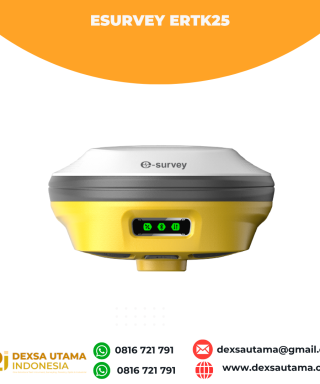
Baca selengkapnyaLaser + CAD AR Dual-Tech Integration AR Stakeout: Overlay CAD designs onto real-world environments via AR, boosting on-site efficiency by 40%. Laser Precision: Achieve centimeter-level accuracy with non-contact measurements, ideal for extreme temperatures or tight spaces. High performance and stability: The eSurvey eRTK25 integrates laser ranging technology and AR vision stakeout, enabling robust centimeter-level positioning …








Ulasan
Belum ada ulasan.