



GPS Recon RC7
The RECON RC7 GPS RTK is a high-precision GNSS/GPS receiver that uses Real-Time Kinematic (RTK) technology for accurate geospatial surveys in real time, often equipped with a camera to assist with stakeout tasks and slope measurements up to 60 degrees, making it an efficient tool for field surveys that require high accuracy without the need for lengthy data post-processing, such as measurements on highways or difficult areas.
Features
- RTK technology can determine highly accurate positions directly in the field.
- An integrated camera facilitates visualization during staking (marking points).
- The slope measurement can measure up to 60 degrees, increasing surveyor safety.
- Suitable for topographic surveys, mapping, construction, and other high-precision field work.
Specifications
| SATELLITE PERFORMANCE | |
| Channels | 1.408 | 1.808 (upgradable) |
| GPS | L1C/A, L2C, L2P(Y), L5 |
| GLONASS | L1, L2 |
| BEIDOU | B1l, B2l, B3l, B1C, B2a, B2b |
| GALILEO | E1, E5a, E5b, E6 |
| QZSS | L1, L2, L5, L6 |
| SBAS | L1, L5 |
| L-Band | B2b, PPP |
| Positioning Rate | 1-20Hz |
| ACCURACY | |
| Code Differential | H: 0.40m (RMS) V: 0.80m (RMS) |
| Static | H: 2.5mm ±0.5ppm (RMS) V: 5mm ±0.5ppm (RMS) |
| Real-time Kinematic | H: 8mm ±1ppm (RMS) V: 15mm ±1ppm (RMS) |
| Network PPK | H: 3mm ±1ppm (RMS) V: 5mm ±1ppm (RMS) |
| IMU MEASUREMENT | |
| Tilt Accuracy (No tilt angle limit) | 2cm within 60° |
| DATA STORAGE | |
| Type & Storage | SSD 8GB External USB Pen Drive |
| Data Transfer | Type-C USB Transfer Supports, FTP/HTTP download |
| Differential Format | RTCM 2.1, RTCM 2.2, RTCM 3.0, RTCM 3.1, RTCM 3.2, NMEA 0183 CMR, CMR+ |
| Static Data Format | DAT, RINEX 2.x, RINEX 3.x, BINEX |
| GPS Output Format | VRS, FKP, MAC |
| Network Model | N-trip fully supported |
| COMMUNICATION | |
| I/O | Type-C (OTG + Fast Charge + Ethernet) |
| Antenna Port | All-in-one port for radio/GPRS antenna |
| Network Modem | Nano-SIM card LTE FDD, LTE TDD, UMTS, GSM |
| UHF Radio | 2W Tx/Rx 410-470MHz |
| Protocol | S-LINK, TrimTalk, Hi-Target, SOUTH, CHC |
| WiFi | IEEE 802.11 a/b/g/n/ac Hotspot/Data Link |
| Bluetooth | Bluetooth 2.1 + EDR and 4.0 |
| NFC | Available |
| POWER SUPPLY | |
| Battery | Internal Li-ion Battery 7.2V, 6.800mAh |
| Operating Time | Static mode 20h Rover mode 15h |
| PHYSICAL | |
| Dimension | 74mm (H), 128mm (W) |
| Weight | 740g |
| Operating Temp. | -30°C to 65°C |
| Storage Temp. | -40°C to 80°C |
| Proof | IP68 water and dust proof 2m drop on hard surface 40G 10ms sawtooth wave |
| INTERFACES | |
| Button | 1 |
| LED Indicator | Data Link, Satellite, Bluetooth, Power |
| CAMERA | |
| Optical Format | 1/5 inch |
| Pixel Size | 1.75*1.75µm |
| Active Pixel Array | 1616*1232 |
| Sensor | 2 mega CMOS imaging sensors |
Hanya pelanggan yang sudah login dan telah membeli produk ini yang dapat memberikan ulasan.
Produk Terkait


GPS SINGULAR XYZ X1
Baca selengkapnyaThe SingularXYZ X1 GNSS Receiver is a lightweight, ultra-compact RTK receiver designed for demanding field conditions. Offering full satellite tracking, tilt compensation, and a long-lasting battery, it delivers consistent high-precision results in any environment.
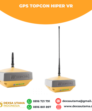
GPS Topcon HiPer VR
Baca selengkapnyaVersatile Performance Better things in smaller packages! The HiPer VR* is compact, light and packed with the most advanced GNSS technology in a design built to withstand the harshest field environments. Using Topcon’s advanced GNSS chipset with Universal Tracking Channels Technology, the HiPer VR automatically tracks every satellite signal above – now and into the future. All …

ESurvey E800
Baca selengkapnyaHigh-performance RTK Receiver
The E800 is a high-performance GNSS receiver that provides an easy-to-use solution for survey professionals who need to collect highly accurate data in a wide range of applications. The durable IP67 design makes it possible to work in extreme environments. The colorful touchscreen is convenient for quick configurations.

 0816 721 791
 dexsautama@gmail.com




Ulasan
Belum ada ulasan.