



Furuno GPS NAVIGATOR GP-170
Full compliance with IMO Performance Standards and IEC Testing Standards
High performances for Radar, AIS, ECDIS, Autopilot, Eco Sounder, other Sensors for Navigation and Communication Equipment
| Function | IMO Perf. Standard | IEC Test Standard |
|---|---|---|
| GPS | MSC.112 (73) | IEC61108-1 |
| GLONASS | MSC.113 (73) | IEC61108-2 |
| DGNSS | MSC.114 (73) | IEC61108-4 |
| MULTI (*) | MSC.115 (73) | — |
| Alert Management | MSC.302 (87) | IEC62923-1/-2 |
*Combined GPS/GLONASS
▶ Newly designed GPS chip and antenna unit deliver enhanced stability and precision in position fixing
Enhanced noise rejection capabilities are incorporated in the GPS receiver chip, delivering high level of tolerance towards multi-path mitigation. Also, the tolerance towards multi-path mitigation is enhanced when the antenna unit is used.
▶ Augmentation to enhance precision by utilizing SBAS (Satellite-Based Augmentation System), DGNSS (Differential Global Navigation Satellite System) and SLAS (Sub-meter Level Augmentation Service)
▶ 10 Hz position update rate (position updated every 0.1 second) making steady own ship position tracking possible
▶ USB port available on the front panel
Routing data, menu setting, user setting can be exported/imported through USB jump drives
▶ Dual configuration for back-up purpose to ensure system availability
Information about waypoints, route and other data set by the operators on one unit can be shared with the other units for functional back-up
▶ BAM (Bridge Alert Management) ready
Meets the specific requirements for alerts and interconnection with Bridge Alert Management in IMO MSC.302 (87)
▶ LAN interface for efficient network integration into a bridge system
The GP-170 is fully Light Weight Ethernet (IEC 61162-450) compatible
▶ 5.7″ color LCD (with 640 x 480 pixels) for data visualization
▶ Simplified menu operation
The operator can navigate through the menu tree either by pressing the cursor pad or pressing the corresponding numbers on the numeric keypad to the menu items
▶ Enhanced route planning/management function available
- Comprehensive range of voyage information to be incorporated in routes
- Streamlined route creation through combination with an external PC (GPX format)
- Sharing the active route information with ECDIS to supplement the ECDIS route monitoring capability
Screenshots
Variety of display modes available: Plotter, Course, Highway, Data and Integrity
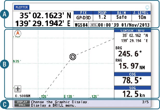

 Positioning Display, Icon Display Area.
 Main Display Area. Please refer to each of the display modes for details.
 Action Guidance and Alert Display Area (under alert situation, the information about the most imminent alert is displayed).
Plotter
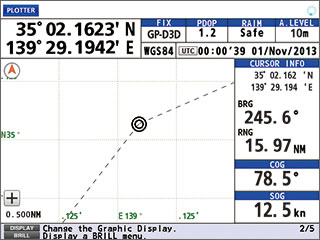
Information to be displayed:
- Simplified plotter display
- Cursor information
- Contextual menu
- SOG/COG data boxes
Integrity
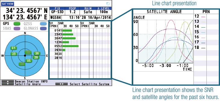
Information to be displayed:
- Skyplot presentation of currently viewable satellites
- Status on GNSS/SBAS satellite signal reception; including.
signal strength/signal to noise ratio (in bar/line charts) - Elevation angles of the available satellites
- Detailed information about the beacon stations
Highway
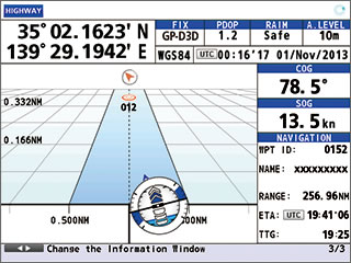
Information to be displayed:
- Course information
- SOG/COG data boxes
- User-preset cross track limit of deviation (XTE)
- Own ship gauge, showing the attitude of the ship, including. pitch, roll and heave
Course
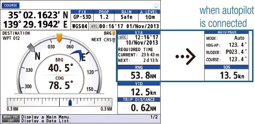
Information to be displayed:
- Graphical presentation of course information, including. current waypoint, bearing to the destination, COG, XTE
- Estimated Time of Arrival data box, including. required time to reach the current/next waypoints and range to the waypoint*
* when autopilot is connected, the following information is shown in the data boxes: Autopilot status data box, including. mode, ship’s heading, rudder angle, and COG, and SOG data box. - Velocity to destination
- Trip distance data
Data
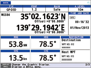
Information to be displayed:
- Navigation data boxes configurable according to the needs of the operators
Brosure
Hanya pelanggan yang sudah login dan telah membeli produk ini yang dapat memberikan ulasan.
Produk Terkait


Furuno Fishfinder FCV-688
Baca selengkapnyaEquipped with Furuno’s latest technology: the Bottom Discrimination Function – Analyze bottom structure* Provides an at-a-glance recognition of bottom from with four types of graphical displays (Rocks/Gravel/Sand/Mud) when connected to required thru-hull or transom mount transducer. * Thru-hull or transom transducer mount required. ACCU-FISH™ – A unique fish size analyzer based on the latest digital …

Furuno GPS/WAAS COLOR CHART PLOTTER GP-3700
Baca selengkapnyaUser customizable keys User customizable keys allow you to create short-cuts to menus. Customize menus before you leave the dock for faster, effortless and more intuitive operation. 12.1 inch large display The larger IPS LCD screen, which features a distinctively clear and wider viewing angle, gives you excellent readability. Huge storage capacity The GP-3700 series …

Furuno Fishfinder FCV-1150
Baca selengkapnya12.1 LCD with AR coated glass filter and anti-polarized sunglass filter Post-processing gain control applies changes to gain setting to all existing returns on the display White Edge bottom discrimination Available Heaving Compensation provides stable echo presentation even in rough seas FURUNO Digital Filter delivers crystal clear target presentation Furuno Free Synthesizer (FFS) allows for …

Furuno GPS/WAAS COLOR CHART PLOTTER with FISH FINDER GP-3700 F
Baca selengkapnyaUser customizable keys User customizable keys are designed to create short-cuts to menus. Customize menus before you leave the dock for faster, effortless and more intuitive operation on the sea. 12.1 inch large display The larger IPS LCD screen, which features a distinctively clear and wider viewing angle, gives you excellent readability in changing sea conditions. Huge …
Furuno GPS/WAAS COLOR CHART PLOTTER with FISH FINDER GP-3700 FRead More






Ulasan
Belum ada ulasan.