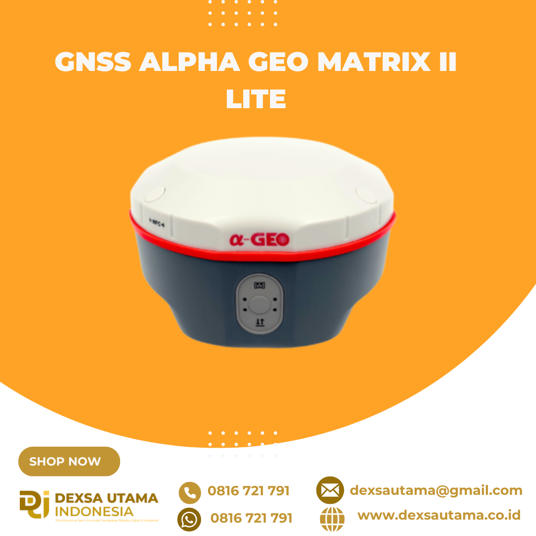
Category
- Uncategorized
- Abney Level
- Accessories GPS Geodetik
- Accessories Lain
- Accessories Survey
- Alat Curah Hujan
- Altimeter
- Anemometer
- Anemometer Kestrel
- Automatic Digital Level
- Automatic Level
- Baterai GPS RTK
- Baterai Total Station & Theodolite
- Borescope Endoscope
- Bushnell H2O
- Bushnell Lainnya
- Bushnell Powerview
- Bushnell Powerview 2
- Curvimeter
- Densiometer
- Detektor Petir
- Diagonal Eyepiece
- Digipas Digital Level
- Disto Meter
- Drone
- Dulang
- Echo Sounder
- Global Water
- GPS Furuno
- GPS Garmin
- GPS Geodetik
- GPS Trimble
- Hammer Test & Profometer
- Hand Lens
- Humidity / Temp
- Inclinometer
- Kabel Locator
- Kamera Trap
- Kompas
- Laser level / Crossline Laser
- LiDAR Laser Scanner
- Meteran
- Nikon Action EX
- Nikon Aculon
- Nikon Monarch
- Notebooks
- Palu Geologi
- Photometer
- Pita Survey/Flagging Tape
- Pocket Microscope
- Prisma Total Station
- Protractor Ruler
- Radar Gun
- Rangefinder
- Rotating Laser level
- Sampel Bag
- Software
- Soil Tester
- Susceptibility Meter
- Tachometer
- Telepon Satelit
- Temperature & Data Logger
- Tension Meter
- Teropong Malam/Night Vision
- Teropong Marine
- Theodolite & Laser Plummet
- Total Station
- Total Station Robotic
- USV
- Water Level Meters
- Weather Station
Popular

GNSS MATRIX II Lite – Solusi Cerdas untuk Survei Presisi Tinggi
GNSS Alpha Geo Matrix II Lite adalah penerima GNSS generasi terbaru yang dirancang untuk memberikan solusi survei yang ringkas, akurat, dan efisien. Dengan desain yang kompak dan ringan, perangkat ini sangat ideal untuk berbagai aplikasi survei, mulai dari pemetaan lahan, konstruksi, hingga pemantauan infrastruktur.
Fitur Unggulan:
Teknologi GNSS Multi-Konstelasi – Mendukung GPS, GLONASS, Galileo, dan BeiDou untuk akurasi maksimal di berbagai kondisi lingkungan.
Desain Kompak & Portabel – Mudah dibawa dan digunakan di lapangan tanpa mengorbankan performa.
Pengolahan Data Real-Time (RTK & PPK) – Memberikan hasil cepat dengan ketelitian tinggi dalam survei.
Baterai Tahan Lama – Dirancang untuk penggunaan jangka panjang tanpa gangguan.
Konektivitas Canggih – Dilengkapi dengan Bluetooth, Wi-Fi, dan port komunikasi fleksibel untuk integrasi yang mudah dengan berbagai perangkat.
Spesifikasi
Performance specification
Satellite signals tracked simultaneously
Channels 1408
Cold start <60 s
Hot start <15 s
Positioning output rate 1Hz-20Hz
GPS: L1 C/A, L2C, L2P, L5 GLONASS: L1, L2, L3
BEIDOU: B1, B2, B3, B1C, B2a, B2b
GALILEO: El/E5a/E5b/E6
QZSS: L1/L2/L5/L6
SBAS: WAAS, EGNOS, MSAS, GAGAN, SDCM
Signal Reacquisition <1s
RTK Initialization time <5s
Initialization Reliability >99.99%
Time accuracy 20 ns
Positioning1
Static GNSS surveying
Horizontal: +(2.5mm + 0.5ppm)
Vertical: ±(5mm + 0.5ppm)
RTK Surveying
Horizontal: +(8mm + 1.0ppm)
Vertical: +(15mm + 1.0ppm)
HARDWARE
PHYSICAL
Material Magnesium alloy
Dimensions 120mm*72mm(without bottom connector 20mm)
weight 0.76kg
Operating temperature -40°C to +75°C
Storage temperature -55°C to +85°C
Protection IP IP67 dust proof, protected from 30min immersion to depth of 1m
Shock Survive 2 m drop onto the concrete
Vibration MIL-STD-810G
Humidity 100%, condensing
IMU
IMU Supported, 4D IMU initialization in 3 seconds
IMU update rate 400Hz
IMU accuracy <2.5cm within 30°
IMU tilt compensation 0-120°
ELECTRICAL
Power 9~24V DC external power
USB Type-C fast charging Support
Battery capacity Internal 7000mAh lithium-ion battery
Working Time
Network Mode >24h
Radio Reception >18h
Radio Transmission >8h
Communication & Data Storage
I/O interface 5pin Lemo port, TNC port
RADIO MODEM
internal radio TX/RX internal module
internal radio frenquency 410-470 MHZ
Communication protocols Alphatalk15, Transparent transmission /TT450S/SOUTH
Bluetooth
Fully integrated Bluetooth V4.0, range ≤ 50m
Data format
Differential data RTCM2.X, RTCM3.X
GPS output data format NMEA 0183s RTK, Binary code
static data format RINEX
Storage
8GB internal memory, supports cyclic storage; with ability to collect over one year raw observation based on 5 seconds interval
Others
System integration
OS system Intelligent LINUX operating system
Supported controllers All android devices with supported software
Design
Key one button
Indicator Power indicator, data link indicator, satellite indicator, Bluetooth indicator
Hanya pelanggan yang sudah login dan telah membeli produk ini yang dapat memberikan ulasan.
Produk Terkait
GPS Hitarget V30 Plus Rover
Baca selengkapnyaHi-Target V30 Plus adalah
sistem Global Navigation Satellite System (GNSS) RTK (Real-Time Kinematic) geodetik, yang dirancang untuk survei dan pemetaan dengan presisi tinggi. Perangkat ini memiliki desain kokoh berkelas industri yang ringkas, dengan mesin GNSS multi-konstelasi untuk pemosisian yang stabil dan akurat bahkan di lingkungan yang sulit.


Ulasan
Belum ada ulasan.