


Kategori: GPS Geodetik
Menampilkan 1–24 dari 95 hasilDiurutkan menurut yang terbaru


GPS Geodetik RTK Comnav Sino Jupiter Laser
Baca selengkapnyaChannel 1668 Satellites tracking GPS: L1C/A, L1C, L2P, L2C, L5 BDS: B1l, B2l, B3l, B1C, B2a, B2b GLONASS: L1, L2, L3 Galileo: E1, E5a, E5b, E6c, E5 AItBOC QZSS: L1C/A, L2C, L5, L1C IRNSS: L5 SBAS: L1C/A PPP: B2b & HAS L-Band Signal Re-acquisition ≤1s Cold Start ≤30s Hot start ≤10s RTK Initialization Time <5s(Baseline≤10km) …

GPS Geodetik RTK Comnav Sino Mars Pro Laser
Baca selengkapnyaThe Mars Pro is an ultra-reliable GNSS receiver with a millimeter-level laser, enabling it to handle complex surveying tasks with unmatched precision, for example, in hard-to-reach, signal-obstructed, and dangerous fields. Mars Pro also features a sunlight-readable OLED color display for user-friendly, high-end operations. Breaking the usual constraints in land surveying, construction, and GIS, it is the go-to choice for professionals looking to elevate their work.- 1668 channels and 60+ satellites tracking capabilities
- Tracking all running and planned constellations, including GPS, BDS-2, BDS-3, GLONASS, Galileo, QZSS, IRNSS, and SBAS
- Up to 120° tilt with 2.5 cm accuracy
- IP67 dust- and waterproof for harsh environments
- Up to 20 hrs non-stop use
- Enabling broader use through extensive protocol support, including Transparent/TT450S/SATEL/Trimtakl3/CHC/South

GPS Geodetik RTK Comnav Sino N2
Baca selengkapnyaSlim-line design makes the N2 one of the most compact GNSS receiver: only 48mm and 0.67kg including battery. Compared with a typical GNSS receiver, it is more than 35% thinner and 40% lighter, can be carried, used and operated more easily without fatigue. Lighter, Thinner, and Stronger – N2 is specifically designed for land survey, marine, precision agriculture, machine control, and GIS.- 1590 channels and 50+ satellites tracking capabilities
- Tracking all running and planned constellations, including GPS, BDS-2, BDS-3, GLONASS, Galileo, QZSS, IRNSS and SBAS
- Up to 15km work range with enhanced UHF
- Up to 120° tilt with 2.5 cm accuracy
- 20+ hrs continuous work with 10000mAh batteries
- Support NFC and Bluetooth connection
- IP67 dust- and waterproof for harsh environments

SatLab Eyr GNSS
Baca selengkapnyaEquipped with dual cameras, the Eyr features image measurement and visual stakeout, which not only provide a wide range of contact-free measurement solutions but also make stakeout operations intuitive and simple. The design of the RTK is aesthetic but practical, and the pocket-sized and lightweight body makes it portable and versatile.

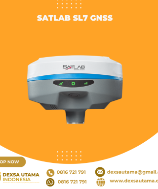
SatLab SL8 Laser GNSS
Baca selengkapnyaSatLab SL8 Laser RTK combines dual cameras, GNSS, IMU,and visible laser technology to make surveying faster and easier. With non-contact measurement, image-assisted targeting, CAD live-view stakeout, and a built-in LoRa radio,It ensures smooth, reliable work even in complex or GNSS-limited environments.
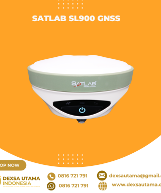
SatLab SL900 GNSS
Baca selengkapnyaThe SatLab GNSS receiver is a high-precision that performs even under the most demanding conditions. With this GNSS receiver, it is capable of delivering highly accurate GPS data in real-time to any device via a Bluetooth connection. Satellite correction service, compact and lightweight, this rtk GNSS is one of the most flexible solutions that promise positioning reliability.

GPS Hitarget V30 Plus Rover
Baca selengkapnyaHi-Target V30 Plus adalah
sistem Global Navigation Satellite System (GNSS) RTK (Real-Time Kinematic) geodetik, yang dirancang untuk survei dan pemetaan dengan presisi tinggi. Perangkat ini memiliki desain kokoh berkelas industri yang ringkas, dengan mesin GNSS multi-konstelasi untuk pemosisian yang stabil dan akurat bahkan di lingkungan yang sulit.
GPS CHCNAV i85
Baca selengkapnyaThe CHCNAV i85 is a compact, high-performance GNSS solution for daily land surveying. Featuring a 1408-channel GNSS module, advanced IMU, integrated dual cameras, and laser rangefinder, it delivers reliable positioning in challenging environments, even under high solar activity. Weighing 800 g with an IP68 rating and 20-hour battery life, the i85 ensures efficient, dependable RTK performance in the field.

GPS CHCNAV i83 Pro
Baca selengkapnyaThe i83 Pro is a 336-channel multi-band IMU-RTK GNSS receiver built for surveying, construction, and mapping professionals. With advanced GNSS technology, including CHCNAV’s iStar algorithm and Trimble RTX and Omnistar options, it ensures consistent accuracy on any site. Its 200 Hz Auto-IMU sensor boosts GNSS RTK survey productivity, making it the perfect tool for demanding field operations.

GPS Hitarget vRTK
Baca selengkapnyaHi-Target vRTKadalah perangkat GNSS geodetik yang menggunakan metode Real-Time Kinematic (RTK) untuk memberikan akurasi posisi tinggi hingga tingkat sentimeter. Salah satu fitur utama yang membedakannya adalah penggunaan teknologi pemosisian visual dengan kamera ganda, yang memungkinkan pengukuran objek tanpa kontak fisik

GPS Hitarget iRTK5
Baca selengkapnyaHi-Target iRTK5 adalahGPS geodetik berteknologi tinggi yang menawarkan solusi survei GNSS RTK (Global Navigation Satellite System Real-Time Kinematic) untuk kebutuhan pemetaan dan konstruksi. Alat ini didesain dengan mesin GNSS generasi terbaru dan teknologi komunikasi nirkabel untuk memberikan akurasi posisi tingkat sentimeter

GPS Hitarget V500
Baca selengkapnyaHi-Target V500 adalahsistem GPS geodetik RTK (Real-Time Kinematic) GNSS yang ringkas dan ringan, dilengkapi dengan berbagai fitur canggih untuk survei dan pemetaan presisi tinggi. Perangkat ini dirancang untuk memberikan akurasi tingkat sentimeter, bahkan dalam kondisi pencahayaan yang kurang ideal.

GPS Hitarget V200
Baca selengkapnyaHi-Target V200 adalahpenerima GNSS RTK (Global Navigation Satellite System Real-Time Kinematic) geodetik yang ringkas dan ringan, dirancang untuk survei dan pemetaan dengan akurasi tinggi. Dengan menggabungkan teknologi multi-konstelasi dan fitur kompensasi kemiringan, perangkat ini menawarkan solusi efisien dan portabel untuk pekerjaan lapangan di berbagai kondisi lingkungan

Controller Alpha GEO S60III Android
Baca selengkapnyaController Alpha GEO S60III : Solusi Handheld Tangguh untuk Surveyor Profesional Dalam dunia pengukuran dan pemetaan, keandalan perangkat adalah kunci utama untuk mendapatkan hasil yang presisi. S60III hadir sebagai data collector terbaru yang dirancang khusus untuk memenuhi kebutuhan surveyor dan profesional pemetaan. Dengan prosesor industri terbaru dari Qualcomm dan berbagai fitur unggulan, S60III siap memberikan …

GPS GNSS Alpha GEO NETBOX2
Baca selengkapnyaNetBOX2: GNSS Receiver Canggih untuk Surveyor Profesional GNSS Alpha GEO NETBOX2 – Buat rekan-rekan surveyor yang mencari GNSS receiver tangguh dengan teknologi terbaru, NetBOX2 dari α-GEO bisa jadi pilihan terbaik. Perangkat ini hadir dengan berbagai fitur canggih yang mendukung pekerjaan pengukuran lahan dengan lebih efisien dan akurat. Yuk, kita bahas fitur-fitur unggulannya! 1. Chipset GNSS …

GPS GNSS Alpha Geo Matrix VI
Baca selengkapnyaGNSS Alpha Geo Matrix VI dengan Teknologi Visual, AR, dan Laser untuk Pengukuran yang Lebih Presisi Mengukur Seakurat Mata Sendiri GNSS Alpha Geo Matrix VI adalah receiver GNSS kelas survey yang menggabungkan teknologi Visual Positioning, algoritma fotogrametri, serta fitur AR dan laser untuk meningkatkan produktivitas surveyor—baik profesional maupun pemula. Dengan perangkat ini, titik-titik yang sebelumnya …


Produk
-
 FLIR TG267
 -
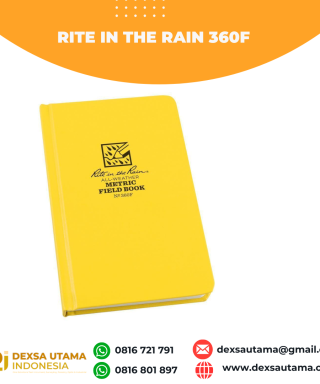 Rite in the Rain 360F
 -
 GPS EFIX F8
 -
 Pole Stick 3.6m
 -
 Mysurv DT202C Rp0 + PPN 11%
 -
 Topcon LN-150 Packages
 -
 Ruide RT2 Rp0 + PPN 11%