



GPS Hitarget V500
sistem GPS geodetik RTK (Real-Time Kinematic) GNSS yang ringkas dan ringan, dilengkapi dengan berbagai fitur canggih untuk survei dan pemetaan presisi tinggi. Perangkat ini dirancang untuk memberikan akurasi tingkat sentimeter, bahkan dalam kondisi pencahayaan yang kurang ideal.
Better visual Stakeout Experience
– Visual positioning technology to find points with ease. The combination of virtual and reality by overlaying the design files with the real scene improves stakeout efficiency.
– Professional-grade starlight night vision HD camera with wide angle. Excellent performance and algorithm in tracking signals, achieving an accuracy of up to 1cm.
– Seamless switch of 360-degree AR stakeout between the handheld controller and the rover brings out immersive stakeout experiences making stakeout fast and accurate.
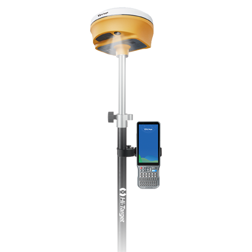
Spesifikasi
GNSS SIGNAL
- Channels: 1760
- GPS: L1CA / L1C / L2P(Y) / L2C / L5
- BDS: B1l / B2l / B3l / B1C / B2a / B2b
- GLONASS: L1/L2/L3
- Galileo: E1 / E5a / E5b / E6
- SBAS: L1 / L2 / L5
- QZSS: L1 / L2 / L5 / L6*
- IRNSS: L5*
- L-BAND*: B2b-PPP*
POSITIONING PERFORMANCE
- High Precision static GNSS Surveying
- Horizontal : 2.5mm + 0.1ppm RMS
- Vertical: 3.5mm + 0.4ppm RMS
- Static and Fast Static
- Horizontal: 2.5mm + 0.5ppm RMS
- Vertical: 5mm + 0.5ppm RMS
- High Precision static GNSS Surveying
- Post Processing Kinematic (PPK / Stop & Go)
- Horizontal: 8mm + 1ppm RMS
- Vertical: 15mm + 1ppm RMS
- Initialization time: Typically 10 min for base and 5 min for rover
- Initialization reliability: Typically > 99.9%
- Post Processing Kinematic (PPK / Stop & Go)
- PPP
- H: 10cm | V: 20cm
- PPP
- Code Differential GNSS Positioning
- Horizontal: ±0.25m + 1ppm RMS
- Vertical: ±0.5m + 1 ppm RMS
- SBAS: 0.5m (H), 0.85m (V)
- Code Differential GNSS Positioning
- Real Time Kinematic (RTK)
- Horizontal: 8mm+1ppm RMS
- Vertical: 15mm+1ppm RMS
- Initialization time: Typically <10s
- Initialization reliability: Typically > 99.9%
- Real Time Kinematic (RTK)
- Time to First Fix
- Cold Start: <45 s
- Hot Start: <30 s
- Signal re-acquisition: <2 s
- Time to First Fix
- Hi-Fix
- Horizontal: RTK+10mm / minute RMS
- Vertical: RTK+20mm / minute RMS
- Hi-Fix
- Tilt Survey Performance
- Additional horizontal pole-tilt uncertainty typically less than 8mm +0.7mm / °tilt (2.5cm accuracy in the inclination of 60°)
- Tilt Survey Performance
- AR Stakeout Accuracy
- 1 cm
- AR Stakeout Accuracy
COMMUNICATION
- I/O Interface
- 1 x USB type C port
- 1 x SMA antenna port
- I/O Interface
- WiFi
- Frequency 2.4GHz
- Support 802.11 a/b/g/n
- WiFi
- Bluetooth
- Bluetooth: 5.2, 2.4GHz
- Bluetooth
- Internal UHF Radio
- Power: 0.5W/1W/2W Adjustable
- Frequence: 410-470MHz
- Protocol: HI-TARGET, TRIMTALK450S, TRIMMARK III, SATEL-3AS, TRANSEOT, etc.
- working range: Typically 3~5km, Optimal 8~15km
- Channel: 116 (16 scalable)
- Internal UHF Radio
CAMERA
- Function
- Professional starlight night vision HD Camera, large viewing angle, support live view stakeout
- Function
CONTROL PANEL
- LED Lamp:
- Satellite
- Signal
- Power
- LED Lamp:
- Physical button: 1
SYSTEM CONFIGURATION
- Storage: 16GB ROM internal storage
- Output format: ASCII: NMEA-0183
- Output Rate: 1Hz~20Hz
- Static Data Rate: GNS, Rinex
- Real Time Kinematic (RTK): RTCM2.X, RTCM3.X
- Network Mode: VRS, FKP, MAC, Support NTRIP Protocol
Brosure
Video
Hanya pelanggan yang sudah login dan telah membeli produk ini yang dapat memberikan ulasan.
Produk Terkait


GPS Geodetik RTK Comnav Sino Jupiter Laser
Baca selengkapnyaChannel 1668 Satellites tracking GPS: L1C/A, L1C, L2P, L2C, L5 BDS: B1l, B2l, B3l, B1C, B2a, B2b GLONASS: L1, L2, L3 Galileo: E1, E5a, E5b, E6c, E5 AItBOC QZSS: L1C/A, L2C, L5, L1C IRNSS: L5 SBAS: L1C/A PPP: B2b & HAS L-Band Signal Re-acquisition ≤1s Cold Start ≤30s Hot start ≤10s RTK Initialization Time <5s(Baseline≤10km) …

CHCNAV DL8 Radio External
Baca selengkapnyaThe DL8 UHF radio modem provides reliable base-to-rover GNSS RTK corrections over long distances. Designed for harsh environments, it supports up to 28 W of adjustable output power, ensuring robust communication even in challenging conditions. With customizable frequency channels and a rugged IP67-rated enclosure, the DL8 is an essential tool for surveyors requiring dependable and high-performance data links.
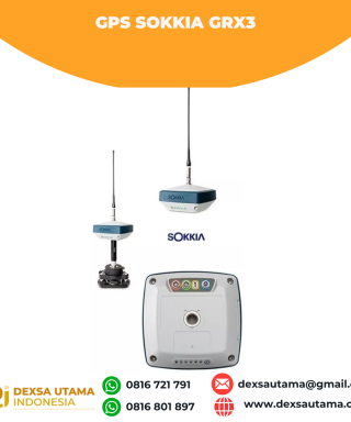
GPS Sokkia GRX3
Baca selengkapnyaNumber of Universal Tracking Channels 226 UTC technology Tracked Signals GPS L1 C/A, L1C, L2P(Y), L2C, L5 GLONASS L1 C/A, L1P, L2 C/A, L2P, L3C BeiDou B1, B2 Galileo E1,E5a, E5b, Alt-BOC SBAS L1 C/A, L5 WAAS/MSAS/EGNOS/GAGAN QZSS L1 C/A, L1C, L1-SAIF, L2C, L5 Static/Fast Static H: 3 mm + 0.4 ppm V: 5 mm …

 0816 721 791
 dexsautama@gmail.com




Ulasan
Belum ada ulasan.