Brand: Comnav Sino
Menampilkan semua 4 hasilDiurutkan menurut yang terbaru


GPS Geodetik RTK Comnav Sino Jupiter Laser
Baca selengkapnyaChannel 1668 Satellites tracking GPS: L1C/A, L1C, L2P, L2C, L5 BDS: B1l, B2l, B3l, B1C, B2a, B2b GLONASS: L1, L2, L3 Galileo: E1, E5a, E5b, E6c, E5 AItBOC QZSS: L1C/A, L2C, L5, L1C IRNSS: L5 SBAS: L1C/A PPP: B2b & HAS L-Band Signal Re-acquisition ≤1s Cold Start ≤30s Hot start ≤10s RTK Initialization Time <5s(Baseline≤10km) …

GPS Comnav Sino Mars Pro Laser
Baca selengkapnyaThe Mars Pro is an ultra-reliable GNSS receiver with a millimeter-level laser, enabling it to handle complex surveying tasks with unmatched precision, for example, in hard-to-reach, signal-obstructed, and dangerous fields. Mars Pro also features a sunlight-readable OLED color display for user-friendly, high-end operations. Breaking the usual constraints in land surveying, construction, and GIS, it is the go-to choice for professionals looking to elevate their work.- 1668 channels and 60+ satellites tracking capabilities
- Tracking all running and planned constellations, including GPS, BDS-2, BDS-3, GLONASS, Galileo, QZSS, IRNSS, and SBAS
- Up to 120° tilt with 2.5 cm accuracy
- IP67 dust- and waterproof for harsh environments
- Up to 20 hrs non-stop use
- Enabling broader use through extensive protocol support, including Transparent/TT450S/SATEL/Trimtakl3/CHC/South

GPS Geodetik RTK Comnav Sino N2
Baca selengkapnyaSlim-line design makes the N2 one of the most compact GNSS receiver: only 48mm and 0.67kg including battery. Compared with a typical GNSS receiver, it is more than 35% thinner and 40% lighter, can be carried, used and operated more easily without fatigue. Lighter, Thinner, and Stronger – N2 is specifically designed for land survey, marine, precision agriculture, machine control, and GIS.- 1590 channels and 50+ satellites tracking capabilities
- Tracking all running and planned constellations, including GPS, BDS-2, BDS-3, GLONASS, Galileo, QZSS, IRNSS and SBAS
- Up to 15km work range with enhanced UHF
- Up to 120° tilt with 2.5 cm accuracy
- 20+ hrs continuous work with 10000mAh batteries
- Support NFC and Bluetooth connection
- IP67 dust- and waterproof for harsh environments
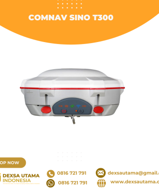
GPS Geodetik RTK Comnav Sino T300
Baca selengkapnyaSince its debut in 2013, the T300 has not only maintained its iconic design, but has also consistently evolved to stay at the forefront of GNSS technology.- GPS L1/L2/L5, BeiDou B1/B2/B3/B1C/B2a/B2b, GLONASS L1/L2/L3, Galileo E1/E5a/E5b/E6/AltBOC, QZSS L1/L2/L5, Navic L5, SBAS
- Compact Design
- Hot Swap Battery
- User-friendly Interface
- Support WIFI/UHF/4G
- Web server for easy configuration