Popular
-

 DEPSTECH DS620 Dua Lens
 -
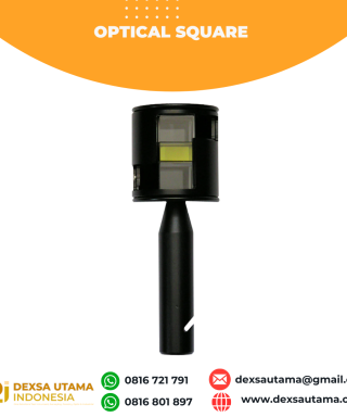 Optical Square
 -
 South Baterai NB28 Rp0 + PPN 11%
 -
 Kolida Charger KC10A Rp0 + PPN 11%
 -
 Solinst 101 P2/M3/600


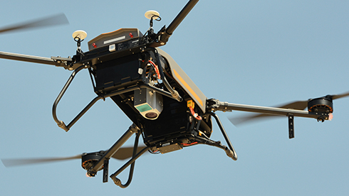

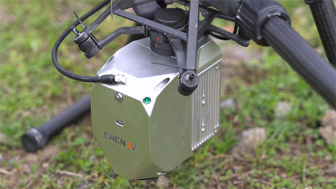
LiDAR CHCNAV AlphaAir 450
The AlphaAir 450 is designed for simplicity and precision, making advanced geospatial reality capture accessible to non-professional users and those new to the technology. At an affordable price, the AA450 combines ease-of-use with high-precision capabilities. This lightweight, durable solution integrates a high-performance laser scanner, a professional-grade 26 MP industrial camera, and a high-precision inertial navigation system to ensure superior data collection quality.
Main Features
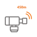 LIVOX AVIA Scanner
Long-range scanning up to 450m.
 26 MP Camera
High-resolution imaging.
 GNSS + IMU
High-precision inertial navigation.
 Skyport Interface
Easy integration with DJI and other UAVs.
High-Precision Data
Achieve high-precision data with the integrated LIVOX AVIA laser scanner and 26 MP industrial camera. Obtain detailed and reliable geospatial data for various applications, from topographic mapping to emergency
Long-Range Scanning
Utilize long-range scanning capabilities up to 450 meters with high point density. Enhance productivity by covering extensive areas quickly and accurately in a single UAV flight.
Cost-Effective Solution
Access advanced LiDAR technology at an affordable price. The AA450 democratizes geospatial reality capture, making it accessible to a wider range of users and applications.
Easy-to-Use Interface
Operate with simplicity using the AlphaAir 450’s intuitive design. Ideal for non-professional users, it enables efficient and accurate data collection without the need for extensive training.
Versatile UAV Integration
Compatible with multiple UAV platforms, including DJI M300/M350 and CHCNAV BB4. The Skyport interface allows seamless integration, ensuring versatility and ease of use.
Enhanced Weather Resistance
Operate confidently in various weather conditions with the IP64 rating, ensuring consistent performance and data quality, even in challenging environments.
Specifications
Brosure
Hanya pelanggan yang sudah login dan telah membeli produk ini yang dapat memberikan ulasan.
Produk Terkait

Laser Scanner Lixel L2
Baca selengkapnyaHandheld Real-Time 3D Reconstruction Laser Scanner Lixel L2: Teknologi Canggih untuk Scanner 3D Dalam dunia survei dan konstruksi, teknologi pemindaian 3D semakin berkembang pesat. Salah satu inovasi terbaru yang menarik perhatian adalah Laser Scanner Lixel L2, sebuah handheld real-time 3D reconstruction laser scanner yang mampu memberikan hasil pemindaian akurat dengan detail luar biasa. Apa saja …

Laser Scanner CHCNAV RS10
Baca selengkapnyaThe RS10 integrates GNSS RTK, laser scanning, and visual SLAM technologies into one single platform. This fusion increases the efficiency and accuracy of both indoor and outdoor 3D scanning and surveying tasks. It gives surveyors the ability to work in areas with weak GNSS signals, providing unparalleled flexibility. Designed for surveying, BIM, forestry, power line inspection, underground mapping, and more, the RS10 embodies versatility, making it an essential tool for professionals looking to expand their surveying capabilities.

Hitarget V700S SLAM RTK
Baca selengkapnyaHi-Target V700S SLAM RTK adalahperangkat GPS Geodetik inovatif yang menggabungkan teknologi Real-Time Kinematic (RTK) dan Simultaneous Localization and Mapping (SLAM). Perpaduan ini memungkinkan pengukuran dengan akurasi tingkat sentimeter, baik di area terbuka dengan sinyal GNSS kuat maupun di lokasi yang sulit dijangkau, seperti terowongan, lorong, atau di bawah jembatan

LiDAR CHCNAV AlphaAir 10
Baca selengkapnyaThe AlphaAir 10 is a professional airborne LiDAR+RGB system designed to meet the demanding requirements of UAV LiDAR mapping and drone photogrammetry. This advanced solution integrates superior LiDAR technology with accurate GNSS positioning, IMU orientation, and a professional full frame orthophoto camera. Together with CHCNAV’s point cloud and image fusion modeling software, the AA10 delivers survey-grade accuracy, efficiency, and cost-effectiveness in 3D data acquisition and processing
Produk
-
 TERSUS OSCAR TREX GNSS Rp0 + PPN 11%
 -
 Furuno GPS/WAAS COLOR CHART PLOTTER GP-3700
 -
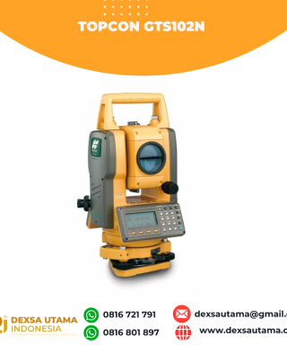 Topcon GTS102N
 -
 TOKNAV DL8635 RADIO EXTERNAL Rp0 + PPN 11%
 -
 Leica Lino L2
 -
 Digipas DWL-280Pro
 -
 South NTS332R10 Rp0 + PPN 11%
Ulasan
Belum ada ulasan.