


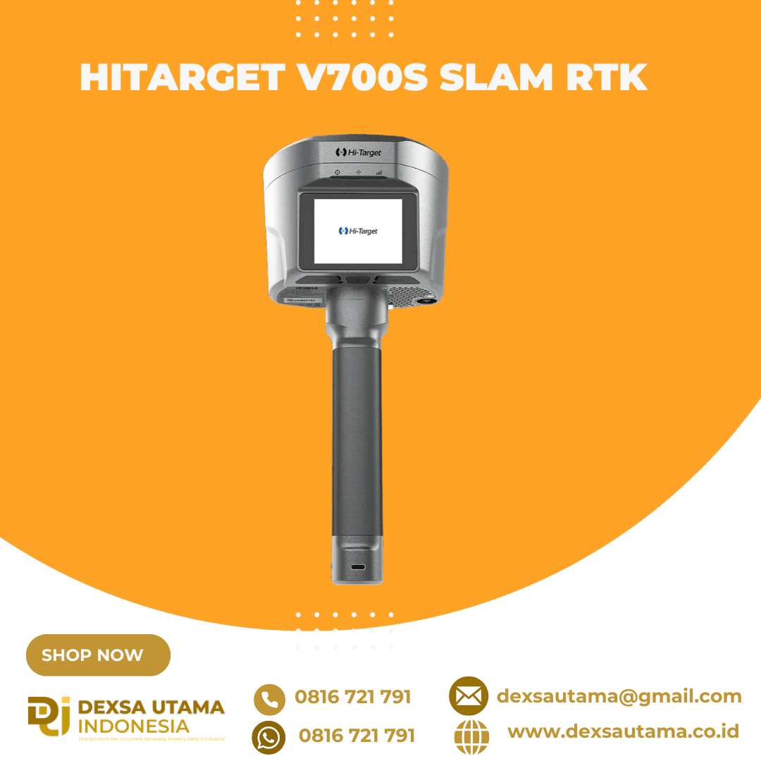
Hitarget V700S SLAM RTK
perangkat GPS Geodetik inovatif yang menggabungkan teknologi Real-Time Kinematic (RTK) dan Simultaneous Localization and Mapping (SLAM). Perpaduan ini memungkinkan pengukuran dengan akurasi tingkat sentimeter, baik di area terbuka dengan sinyal GNSS kuat maupun di lokasi yang sulit dijangkau, seperti terowongan, lorong, atau di bawah jembatan
One Coordinate System, Zero Hassle
RTK and SLAM fusion ensures real-time positioning with unified output (BLH/NEZ). No control points needed—scan freely, without retracing your steps.

Spesifikasi
GNSS Configuration
- Channel: 1408
- GNSS Signal:
- GPS: L1C/A, L1C, L2P(Y), L2C, L5
- BDS: B1I, B2I, B3I, B1C, B2a, B2b
- GLONASS: L1, L2, L3
- GALILEO: E1, E5a, E5b, E6
- QZSS: L1, L2, L5, L6
- NavIC: L5
- SBAS: L1, L2, L5
- PPP: B2b-PPP, E6-HAS
- Output format: ASCII: NMEA-0183, Binary
- Output rate: 1Hz~20Hz
- Static data format: GNS, Rinex
- Real Time Kinematic: RTCM2.X, RTCM3.X
- Network Mode: VRS, FKP, MAC, Support NTRIP protocol
System Configuration
- Operation system: Linux
- Storage: Circulating 512GB ROM
Accuracy and Reliability
- High-Precision Static: H: 2.5 mm + 0.1 ppm RMS, V: 3.5 mm + 0.4 ppm RMS
- Static and Fast Static: H: 2.5 mm + 0.5ppm RMS, V: 5 mm + 0.5ppm RMS
- PPK: H: 8mm + 1ppm RMS, V: 15mm + 1ppm RMS
- PPP: H: 10cm, V: 20cm
- Code Differential GNSS Positioning: H: ±0.25m+1ppm RMS SBAS: 0.5m (H), 0.85m (V), V: ±0.5m+1ppm RMS
- Real Time Kinematic (RTK): H: 8mm+1ppm RMS Initialization time: Typically <10s, V: 15mm+1ppm RMS Initialization reliability: Typically > 99.9%
- Tilt Survey Performance: 8mm+0.3mm/°tilt
- AR Stakeout: Support
- Image measurement: A single photo can acquire multiple point coordinates, with an accuracy of better than 5cm within 15 meters
- Real-time accuracy evaluation: Supports
Camera
- Pixel: 3 Professional HD Cameras
- Function: Support AR stakeout, image measurement, working distance 2~15m
Laser Scanner
- Range: 0.1~ 40m@10%, 0.1~ 70m@80%
- Point Measurement Rate: 200,000 pts/sec
- Laser product classification: Class 1 Eye Safe
- FOV: H: 160°, V: 59°
IMU
- Update rate: 200Hz
Communication
- I/O Interface: USB type C port; SMA antenna port; Nano SIM card slot
- Network: TDD-LTE,FDD-LTE,GSM
- WiFi: IEEE 802.11a/b/g/n/ac/ax,2.4GHz/5GHz,Wifi hotspot
- Bluetooth: Bluetooth 5.2
- Internal UHF Radio:
- Power:0.5W/1W Adjustable Frequence: 410MHz~470MHz
- Protocol: HI-TARGET, TRIMTALK450S, TRIMMARK III, SATEL-3AS, TRANSEOT, etc.
- Channel: 116(16 scalable)
Sensor
- Electronic bubble: Supports
- Tilt Survey: Built-in High-precision IMU Module
Control Panel
- Physical button: Single button
- Display: 2.8 inch, 480×640 pixel touchable screen
- LED lights: Mode, Accuracy, Network
Application
- Advanced function: NFC, WebUI, Firmware upgrade via U-disk
- Intelligence application: Intelligent Voice, Self-check
- Remote service: Message push, online upgrade, remote control
Physical
- Power:
- Lithium battery, portable charger
- RTK rover(UHF/Cellular): up to 10 hours, SLAM mode: up to 5 hours
- USB 45W fast charging, fully charged in 2 hours
- Size: fully charged in 2 hours
- Weight: 68kg
- Power:
Environments
- Water/dustproof: IP64
- Humidity: 100% non-condensing
- Operation temperature: -20°C~+55°C
- Storage temperature: -40°C~+70°C
Brosure
Video
Hanya pelanggan yang sudah login dan telah membeli produk ini yang dapat memberikan ulasan.
Produk Terkait


LiDAR CHCNAV AlphaAir 15
Baca selengkapnyaThe AlphaAir 15 (AA15) is a lightweight, high-performance airborne LiDAR system designed for large-scale operations where high-density data capture is crucial. With a range of up to 1800 meters and the ability to produce 2 million pulses per second, the AA15 is ideal for mapping and geospatial applications, including corridor mapping, urban planning, and vegetation analysis. Its compact design allows for easy integration with UAVs, small aircraft, and helicopters.

SatLab SL9 SLAM RTK
Baca selengkapnyaSatLab SL9 SLAM RTK combines high-precision GNSS positioning with cutting-edge SLAM technology, eliminating the spatial constraints of traditional RTK measurements. Whether in urban buildings, dense forests, or indoor environments, SL9 ensures reliable, precise measurements, redefining efficiency and versatility in fieldwork

Laser Scanner Lixel L2
Baca selengkapnyaHandheld Real-Time 3D Reconstruction Laser Scanner Lixel L2: Teknologi Canggih untuk Scanner 3D Dalam dunia survei dan konstruksi, teknologi pemindaian 3D semakin berkembang pesat. Salah satu inovasi terbaru yang menarik perhatian adalah Laser Scanner Lixel L2, sebuah handheld real-time 3D reconstruction laser scanner yang mampu memberikan hasil pemindaian akurat dengan detail luar biasa. Apa saja …

Laser Scanner CHCNAV RS10
Baca selengkapnyaThe RS10 integrates GNSS RTK, laser scanning, and visual SLAM technologies into one single platform. This fusion increases the efficiency and accuracy of both indoor and outdoor 3D scanning and surveying tasks. It gives surveyors the ability to work in areas with weak GNSS signals, providing unparalleled flexibility. Designed for surveying, BIM, forestry, power line inspection, underground mapping, and more, the RS10 embodies versatility, making it an essential tool for professionals looking to expand their surveying capabilities.


Ulasan
Belum ada ulasan.