Brand: CHC
Menampilkan semua 20 hasilDiurutkan menurut yang terbaru
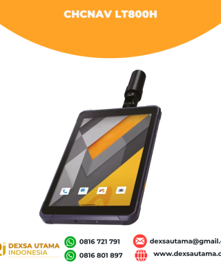

CHCNAV LT800H
Baca selengkapnyaThe LT800H RTK Android tablet increases the productivity of mobile workforces. Designed for centimeter-to-decimeter accuracy, it excels in precision GIS data collection, forensic mapping, construction layouts, environmental studies, and landscaping projects. Its sunlight-readable 8.1″ display ensures that GIS data maps and images are clear even in bright sunlight. Its rugged IP67-rated design withstands harsh conditions, making it the first choice for teams in challenging environments
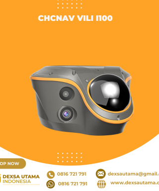
CHCNAV ViLi i100
Baca selengkapnyaThe ViLi i100 is CHCNAV’s flagship GNSS RTK receiver, combining advanced satellite filtering, enhanced SFix 2.0 positioning and innovative Vi-LiDAR technology. It provides reliable, centimetre-level accuracy even in challenging GNSS environments, allowing professionals to extend the boundaries of traditional GNSS surveying.

GPS CHCNAV i85
Baca selengkapnyaThe CHCNAV i85 is a compact, high-performance GNSS solution for daily land surveying. Featuring a 1408-channel GNSS module, advanced IMU, integrated dual cameras, and laser rangefinder, it delivers reliable positioning in challenging environments, even under high solar activity. Weighing 800 g with an IP68 rating and 20-hour battery life, the i85 ensures efficient, dependable RTK performance in the field.

GPS CHCNAV i83 Pro
Baca selengkapnyaThe i83 Pro is a 336-channel multi-band IMU-RTK GNSS receiver built for surveying, construction, and mapping professionals. With advanced GNSS technology, including CHCNAV’s iStar algorithm and Trimble RTX and Omnistar options, it ensures consistent accuracy on any site. Its 200 Hz Auto-IMU sensor boosts GNSS RTK survey productivity, making it the perfect tool for demanding field operations.

Drone CHCNAV X500
Baca selengkapnyaThe CHCNAV X500 rotor UAV is a professional drone engineered for exceptional payload capacity and endurance. Equipped with advanced flight controls and high-precision positioning, it delivers superior maneuverability, stability, and flight performance. Its built-in visual SLAM and obstacle detection radar ensure intelligent, safe operations. Compatible with CHCNAV sensors and third-party payloads, the X500 is ideal for applications such as surveying, urban surveillance, emergency scouting, disaster relief, and inspection missions.

LiDAR CHCNAV AlphaAir 15
Baca selengkapnyaThe AlphaAir 15 (AA15) is a lightweight, high-performance airborne LiDAR system designed for large-scale operations where high-density data capture is crucial. With a range of up to 1800 meters and the ability to produce 2 million pulses per second, the AA15 is ideal for mapping and geospatial applications, including corridor mapping, urban planning, and vegetation analysis. Its compact design allows for easy integration with UAVs, small aircraft, and helicopters.

LiDAR CHCNAV AlphaAir 10
Baca selengkapnyaThe AlphaAir 10 is a professional airborne LiDAR+RGB system designed to meet the demanding requirements of UAV LiDAR mapping and drone photogrammetry. This advanced solution integrates superior LiDAR technology with accurate GNSS positioning, IMU orientation, and a professional full frame orthophoto camera. Together with CHCNAV’s point cloud and image fusion modeling software, the AA10 delivers survey-grade accuracy, efficiency, and cost-effectiveness in 3D data acquisition and processing

LiDAR CHCNAV AlphaAir 450
Baca selengkapnyaThe AlphaAir 450 is designed for simplicity and precision, making advanced geospatial reality capture accessible to non-professional users and those new to the technology. At an affordable price, the AA450 combines ease-of-use with high-precision capabilities. This lightweight, durable solution integrates a high-performance laser scanner, a professional-grade 26 MP industrial camera, and a high-precision inertial navigation system to ensure superior data collection quality.

Laser Scanner CHCNAV RS10
Baca selengkapnyaThe RS10 integrates GNSS RTK, laser scanning, and visual SLAM technologies into one single platform. This fusion increases the efficiency and accuracy of both indoor and outdoor 3D scanning and surveying tasks. It gives surveyors the ability to work in areas with weak GNSS signals, providing unparalleled flexibility. Designed for surveying, BIM, forestry, power line inspection, underground mapping, and more, the RS10 embodies versatility, making it an essential tool for professionals looking to expand their surveying capabilities.

CHCNAV CTS-A100 Total Station
Baca selengkapnyaThe CTS-A100 is a reflectorless total station optimized for efficient fieldwork, featuring the Android OS and CHCNAV’s LandStar software for intuitive, high-performance surveying. Its powerful EDM system offers a range of 5000 m with a prism and 1500 m without a reflector. Its built-in Qualcomm octa-core processor ensures smooth operation. The CTS-A100 is perfect for everyday surveying tasks such as construction layout and topographic mapping, providing accurate and reliable data collection.

GPS CHCNAV i89
Baca selengkapnyaThe i89 is a compact yet powerful surveying tool with a 1408-channel GNSS module that enhances RTK performance in challenging conditions. Its advanced ionospheric modeling ensures reliable RTK fixes, even during high solar activity. With 16.5 hours of battery life and a lightweight 750 g design, the i89 delivers efficiency and ease for daily surveying tasks.

CHCNAV HCE600
Baca selengkapnyaThe HCE600 is a lightweight, professional Android data collector designed for field surveying and mapping. With a 5.5-inch DragonTrail™ display, it offers exceptional durability and clear visibility in sunlight. Packed with Bluetooth 5.0, dual-band Wi-Fi, and a 4G modem, it ensures seamless connectivity with GNSS receivers and RTK networks. Certified to IP67 and MIL-STD-810H standards, the HCE600 is built to withstand harsh environments, making it the ideal handheld controller for reliable data collection in any conditions

GPS CHCNAV iBase
Baca selengkapnyaThe iBase GNSS receiver offers a streamlined solution as a GNSS base station designed to meet surveyor’s needs. Its performance rivals that of a standard external UHF radio modem without the bulk of external batteries, cables, radios, and antennas. With a 5-watt radio module, it provides GNSS RTK coverage up to 25 km under optimal conditions. Its real-time UHF interference self-checking capability allows operators to select the best frequency channel, increasing ease of use and efficiency. In addition, iBase’s integrated AUTO-IMU enhances its functionality as a GNSS rover.

GPS CHCNAV i73+
Baca selengkapnyaThe i73+ GNSS is a compact receiver with a built-in UHF modem, perfect for base station or rover applications. Its automatic pole tilt compensation boosts point measurement efficiency by 20% and improves stakeout productivity by 30%. Lightweight and portable, the i73+ enhances survey comfort, adapting easily to various job sites and reducing operator fatigue.

GPS CHCNAV i76
Baca selengkapnyaThe i76 Palm Visual RTK is a lightweight receiver combining GNSS, IMU, and dual cameras. Weighing just 450g and IP68-rated, it maintains a 96% fixed rate even in areas with high solar activity. Its CAD AR visual stakeout enables precise path planning, while the 5th Gen Ultra-IMU ensures accuracy even at a 60° tilt. With over 17 hours of battery life, the i76 offers precision and adaptability for professionals seeking precision and adaptability.

GPS CHCNAV i83
Baca selengkapnyaThe i83 GNSS receiver is a powerful IMU-RTK GNSS solution built for surveying, construction, and mapping professionals. Equipped with Wi-Fi, Bluetooth, NFC, UHF, and a 4G modem, it delivers versatile connectivity across multiple applications. Its power management allows 34 hours of continuous RTK rover operation, ensuring reliable performance for extended fieldwork.

GPS CHCNAV i93
Baca selengkapnyaThe i93 Visual IMU-RTK GNSS receiver combines advanced GNSS, IMU, and dual-camera video-photogrammetry to deliver a superior user experience. Its 3D visual stakeout and offset measurement features boost efficiency on construction sites. Powered by the CHCNAV iStar algorithm, it uses multi-band GNSS channels and hybrid positioning for reliable accuracy in challenging environments, making it a versatile tool for any project.

CHCNAV D390 Integrated Single Beam Echosounder
Baca selengkapnyaThe D390 is a portable and cost-effective bathymetric system designed for professional hydrographic surveys. Equipped with a high-performance 200 kHz transducer, it adapts to varying hydrographic conditions, ensuring precise depth measurements. The D390’s 7-degree beam angle provides focused directional and lateral resolution, while the 12-inch HD touchscreen and feature-rich HydroSurvey software simplify survey operations and data management.

Software CHCNAV CGO Post Processing
Baca selengkapnyaCGO software is designed to edit, process, and analyze GNSS data, delivering high-precision positioning results for a wide range of applications. It serves as a sophisticated yet user-friendly platform bridging the gap between field survey activities and GNSS post-processing needs. Ideal for geodetic and surveying tasks, UAV trajectography, ground control points (GCPs), and road construction projects, CGO ensures efficient and accurate workflow from data collection to final analysis.

CHCNAV DL8 Radio External
Baca selengkapnyaThe DL8 UHF radio modem provides reliable base-to-rover GNSS RTK corrections over long distances. Designed for harsh environments, it supports up to 28 W of adjustable output power, ensuring robust communication even in challenging conditions. With customizable frequency channels and a rugged IP67-rated enclosure, the DL8 is an essential tool for surveyors requiring dependable and high-performance data links.