


Laser Scanner CHCNAV RS10
The RS10 integrates GNSS RTK, laser scanning, and visual SLAM technologies into one single platform. This fusion increases the efficiency and accuracy of both indoor and outdoor 3D scanning and surveying tasks. It gives surveyors the ability to work in areas with weak GNSS signals, providing unparalleled flexibility. Designed for surveying, BIM, forestry, power line inspection, underground mapping, and more, the RS10 embodies versatility, making it an essential tool for professionals looking to expand their surveying capabilities.
Main Features
 GNSS RTK + SLAM
Combine RTK, laser, and visual SLAM to achieve 5cm absolute accuracy.
 Real-Time Mapping
Real-time georeferenced point clouds in the field.
 High-Precision
1 cm relative accuracy with GNSS and LiDAR technologies.
 Hot-Swappable Battery
60 minutes per battery with hot-swap capability for uninterrupted operation.
Integrated GNSS RTK and SLAM
Combine GNSS RTK and SLAM for unparalleled flexibility. The RS10 ensures precise data collection in areas with weak or no GNSS signals, enhancing indoor and outdoor surveying accuracy.
High-Precision Measurement
Achieve 5 cm absolute measurement accuracy with the 4th generation GNSS antenna and high-precision LiDAR. The RS10 delivers reliable data for detailed architectural surveys and complex infrastructure projects.
Real-Time SLAM Mapping
The RS10 creates georeferenced point clouds directly in the field with real-time SLAM capabilities. It provides immediate feedback on collected data, allowing for on-the-fly adjustments to ensure complete coverage.
Efficient Loop-Free Workflow
Eliminate the need for traditional loop closure with integrated GNSS and SLAM technologies to simplify field data collection and reduce project completion time and effort.
Versatile Application Support
Use the RS10 for a wide range of applications, from BIM and forestry to power line inspection and underground mapping. Its versatility makes it an invaluable tool for professionals in various fields.
Comprehensive Software Integration
The RS10 streamlines your workflow with the SmartGo and CoPre software for real-time data visualization and point cloud processing. It supports efficient and accurate data management from collection to modeling.
Durable and Lightweight Design
Operate in challenging environments with the IP64-rated, lightweight RS10. The robust design ensures reliability and ease of use in diverse conditions.
Hot-Swappable Battery
Maintain continuous operation with the hot-swappable lithium battery. The RS10 offers 60 minutes of runtime per battery, allowing for seamless replacement without powering off the unit.
Specifications
Brosure
Hanya pelanggan yang sudah login dan telah membeli produk ini yang dapat memberikan ulasan.
Produk Terkait


LiDAR CHCNAV AlphaAir 15
Baca selengkapnyaThe AlphaAir 15 (AA15) is a lightweight, high-performance airborne LiDAR system designed for large-scale operations where high-density data capture is crucial. With a range of up to 1800 meters and the ability to produce 2 million pulses per second, the AA15 is ideal for mapping and geospatial applications, including corridor mapping, urban planning, and vegetation analysis. Its compact design allows for easy integration with UAVs, small aircraft, and helicopters.
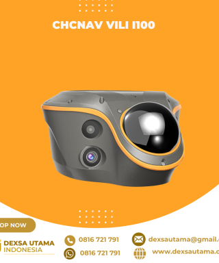
CHCNAV ViLi i100
Baca selengkapnyaThe ViLi i100 is CHCNAV’s flagship GNSS RTK receiver, combining advanced satellite filtering, enhanced SFix 2.0 positioning and innovative Vi-LiDAR technology. It provides reliable, centimetre-level accuracy even in challenging GNSS environments, allowing professionals to extend the boundaries of traditional GNSS surveying.

LiDAR CHCNAV AlphaAir 450
Baca selengkapnyaThe AlphaAir 450 is designed for simplicity and precision, making advanced geospatial reality capture accessible to non-professional users and those new to the technology. At an affordable price, the AA450 combines ease-of-use with high-precision capabilities. This lightweight, durable solution integrates a high-performance laser scanner, a professional-grade 26 MP industrial camera, and a high-precision inertial navigation system to ensure superior data collection quality.

SatLab SL9 SLAM RTK
Baca selengkapnyaSatLab SL9 SLAM RTK combines high-precision GNSS positioning with cutting-edge SLAM technology, eliminating the spatial constraints of traditional RTK measurements. Whether in urban buildings, dense forests, or indoor environments, SL9 ensures reliable, precise measurements, redefining efficiency and versatility in fieldwork


Ulasan
Belum ada ulasan.