


Garmin Striker Plus 4
4” GPS Fishfinder with Industry-leading Sonar and Quickdraw Contours Mapping Software
- Includes dual-beam transducer with Garmin CHIRP traditional sonar for crystal-clear images and remarkable target separation
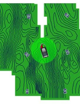
- Built-in Garmin Quickdraw™ Contours mapping software lets you create and store maps with 1’ contours for up to 2 million acres
- Built-in GPS lets you mark waypoints, create routes and view boat’s speed
- Bright, sunlight-readable 4.3” display and intuitive user interface
- Rugged design for every fishing environment

The STRIKER Plus 4 fishfinder with a bright 4.3” display and built-in GPS features CHIRP sonar for crystal-clear images and Quickdraw Contours map drawing software, which stores up to 2 million acres of content with 1’ contours. The built-in GPS lets you mark and navigate to waypoints and shows your boat’s speed.
Garmin Quickdraw Contours
Nobody knows the waters you fish better than you and your fellow fishermen. While you are trolling the shorelines and the depths, Quickdraw Contours mapping software creates HD fishing maps of the places you’ve been. No special knowledge is required. STRIKER Plus 4 can now store up to 2 million acres of your Quickdraw Contours maps with 1’ contours.
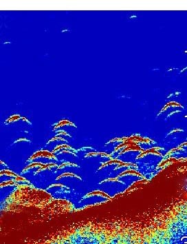
CHIRP Sonar Clarity
The STRIKER Plus 4 fishfinder includes Garmin CHIRP technology for a higher level of clarity and detail that you have come to expect from Garmin. Crystal-clear sonar images provide remarkable target separation and resolution in shallow and deeper water. Bottom contours are more visible, even at higher speeds, and signal noise can be suppressed at greater depths for a timely interpretation of what’s below.
GPS Fishfinder
The built-in, high-sensitivity GPS finds and maintains your position anywhere you go on the water. The GPS allows you to mark waypoints for different locations. So, if the fish are biting in 1 spot, you can mark it, and return to it on your next trip. Mark docks, boat ramps and other locations on the lake, and create routes back to them for your next trip.
GPS also allows STRIKER Plus 4 to show your speed on screen, so you can be sure you’re trolling at the right speed for the lure you’re using or in wake-controlled areas.
Built for You
The STRIKER Plus 4 fishfinder makes fishing a breeze, and it’s built to work in any environment. The bright, sunlight-readable display gives you a clear view of what is below your boat, even on the brightest days. And the larger screen gives you a better view of what is happening below the boat. The intuitive user interface makes it simple to navigate to whatever feature you need, so you are ready for anything on the water.
General | |
| DIMENSION | 3.9” x 6.9” x 1.8” (9.8 x 17.4 x 4.5 cm) |
|---|---|
| WEIGHT | 0.7 lbs (0.3 kg) |
| WATERPROOF | IPX7 |
| DISPLAY TYPE | QSVGA |
| DISPLAY RESOLUTION | 272 X 480 pixels |
Sonar Features & Specifications | |
| FREQUENCY | Traditional: 50/77/83/200 kHz |
|---|---|
| TRANSMIT POWER | 200 W (RMS) |
| BOTTOM LOCK (SHOWS RETURN FROM THE BOTTOM UP) | |
| WATER TEMPERATURE LOG | |
Fishfinder Features | |
| SPLIT-SCREEN ZOOM | |
|---|---|
| FISH SYMBOL ID (HELPS IDENTIFY FISH TARGETS) | |
| AUTOGAIN TECHNOLOGY (MINIMIZES CLUTTER; MAXIMIZES TARGETS) | |
| ADJUSTABLE DEPTH LINE (MEASURES DEPTH OF UNDERWATER OBJECTS) | |
| A-SCOPE (REAL TIME DISPLAY OF FISH PASSING THROUGH TRANSDUCER BEAM) | |
| WATER TEMPERATURE SENSOR INCLUDED | |
Additional | |
| ADDITIONAL |
|
|---|---|
Hanya pelanggan yang sudah login dan telah membeli produk ini yang dapat memberikan ulasan.
Produk Terkait


GPS Garmin GPSMAP 67
Baca selengkapnyaGO EXPLORE THE OUTDOORS Lakukan lebih banyak petualangan dengan perangkat genggam premium tangguh ini. Dapatkan masa pakai baterai yang panjang dan teknologi multi-band untuk akurasi yang lebih baik serta peta TopoActive bawaan dan akses ke gambar satelit. Lihat rute Anda dengan jelas pada layar berwarna 3 inci yang mudah dibaca di bawah sinar matahari. Pergi …

Garmin GMR 18HD+
Baca selengkapnyaDome 4 kW yang Ringkas dan Langsing Radar dome 18-inch 4 kW yang ringkas Menghantarkan 4 kW kekuatan pancar dan echo definition yang jelas di segala jangkauan Dynamic Auto Gain secara otomatis melakukan penyesuaian dengan area sekitar anda untuk medapatkan performa maksimal di segala kondisi Dynamic Sea Filter secara otomatis melakukan penyesuaian untuk mendapatkan informasi …

Garmin GT15M-TH
Baca selengkapnyaTransduser GT15M-TH sempurna untuk pemancing yang menginginkan definisi dasar yang jelas di bawah kapal serta lengkungan ikan yang tajam, jernih dan lebar dengan pemisahan target yang sangat baik hingga kedalaman hingga 1000 kaki. Transduser 8-pin memiliki fitur sonar tradisional CHIRP mid band (85-165 kHz) dan memiliki daya rata-rata 600 W. Rumahan dan gagang thru-hull perunggu …

Garmin GT20-TM
Baca selengkapnyaFor the shallow water anglers who wants traditional and CHIRP ClearVü scanning sonar, this transom or trolling motor mounted transducer consistently displays fish arches as well as clear pictures of objects, structure and fish that pass below your boat. The 20 ft transducer cable with built-in fast response temperature sensor has a power rating of …


Ulasan
Belum ada ulasan.