



SatLab SL900 GNSS
The SatLab GNSS receiver is a high-precision that performs even under the most demanding conditions. With this GNSS receiver, it is capable of delivering highly accurate GPS data in real-time to any device via a Bluetooth connection. Satellite correction service, compact and lightweight, this rtk GNSS is one of the most flexible solutions that promise positioning reliability.
Tilt compensation solution
With surveyors in mind, SatLab GNSS designed a solution to increase efficiency in your workflow by cutting down time wasted from offsetting slanted measurements. With the tilt compensator and GNSS antenna, the GNSS Receiver can save up to 20 percent of time compared to conventional surveying practices. This GNSS solution allows you to focus on your surroundings conveniently while ensuring your safety and comfort.
Efficient and dependable
Powered by the advanced engine, this receiver offers precise positioning and advanced interference mitigation which performs even in the most remote or challenging environments. Using its 1408 channel tracking capabilities, it can track all current and upcoming signals, offering sub-metre excellently to centimetre precise positioning with different modes (RTK, PPK, Static).
Satellite correction service
The GNSS Receiver has TerraStar capabilities that use a global network of multi-GNSS reference stations and advanced algorithms to generate highly precise GNSS satellite orbit, clock, biases, and other system parameters. These data allow TerraStar

Brosure
Hanya pelanggan yang sudah login dan telah membeli produk ini yang dapat memberikan ulasan.
Produk Terkait


CHCNAV DL8 Radio External
Baca selengkapnyaThe DL8 UHF radio modem provides reliable base-to-rover GNSS RTK corrections over long distances. Designed for harsh environments, it supports up to 28 W of adjustable output power, ensuring robust communication even in challenging conditions. With customizable frequency channels and a rugged IP67-rated enclosure, the DL8 is an essential tool for surveyors requiring dependable and high-performance data links.
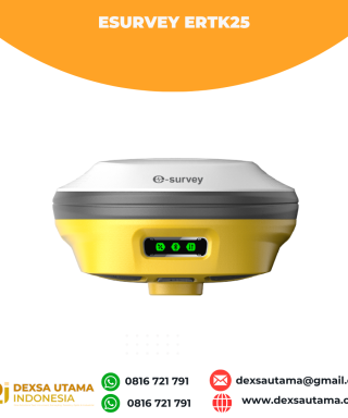
eSurvey eRTK25
Baca selengkapnyaLaser + CAD AR Dual-Tech Integration AR Stakeout: Overlay CAD designs onto real-world environments via AR, boosting on-site efficiency by 40%. Laser Precision: Achieve centimeter-level accuracy with non-contact measurements, ideal for extreme temperatures or tight spaces. High performance and stability: The eSurvey eRTK25 integrates laser ranging technology and AR vision stakeout, enabling robust centimeter-level positioning …


 0816 721 791
 dexsautama@gmail.com





Ulasan
Belum ada ulasan.