



GPS Emlid Reach RX
Lightweight and easy-to-use multi-band RTK GNSS receiver
Designed specifically for work with NTRIP corrections.
Comes with a mobile app.
GNSS
GPS/QZSS L1C/A, L2C,
GLONASS L1OF, L2OF,
BeiDou B1I, B2I,
Galileo E1-B/C, E5b
250 g
Compact and lightweight
16 hrs
Li-Ion battery, USB Type-C charging
Communication interface
Bluetooth 4.2
Package includes
– Reach RX
– USB Type-C cable
Brosure
Hanya pelanggan yang sudah login dan telah membeli produk ini yang dapat memberikan ulasan.
Produk Terkait
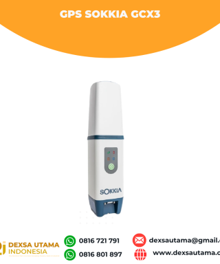

GPS Sokkia GCX3
Baca selengkapnyaGet centimeter-level results without being weighed down by your equipment. This compact receiver delivers full-featured, high-precision performance. The GCX3 is the ideal local job site base/rover RTK (Real Time Kinematic) system or network RTK rover – and like all of our solutions, you can customize it to meet your needs and create your own workflows. …

ESurvey E600
Baca selengkapnyaThe new e-survey E600 GNSS Receiver is coming to change the scene in the high-end GNSS receiver market. With up to 800 true channels and surprising performance, it is destined to be the perfect ally of the topographer – and not only – in the pursuit of perfection. E600 supports all the new technologies (Tilt …

GPS Hitarget V30 Plus Rover
Baca selengkapnyaHi-Target V30 Plus adalah
sistem Global Navigation Satellite System (GNSS) RTK (Real-Time Kinematic) geodetik, yang dirancang untuk survei dan pemetaan dengan presisi tinggi. Perangkat ini memiliki desain kokoh berkelas industri yang ringkas, dengan mesin GNSS multi-konstelasi untuk pemosisian yang stabil dan akurat bahkan di lingkungan yang sulit.

 0816 721 791
 dexsautama@gmail.com






Ulasan
Belum ada ulasan.