

Kabel Locator Leica DSX
For utility repair and maintenance, civil engineering and surveying companies, the Leica DSX utility detection solution, consisting of portable hardware with intuitive software allows to easily locate, visualise and map utilities. Unlike any other ground-penetrating radar (GPR) system, the Leica DSX maximises productivity with cutting-edge software that automates data analysis and creates a 3D utility map on the field.
Easy to use
- Ensure smooth and accurate underground utility detection without expert knowledge
- Complete utility detection and mapping in just a few steps through the intuitive user interface
- Scan anywhere and at any time, even in narrow areas and under severe conditions
Reliable Detection Results
- Detect all types of underground utilities in high resolution to assure reliable avoidance zones
- Verify detected utilities with support of smart algorithm
- Import of POI’s and utility records to help you make better decisions
Instant 2D/3D Utility Map
- Save your time on site by mapping underground utilities in just minutes
- Export utilities in CAD or BIM-read formats for further usage
- Create professional reports, customised to your and your customers’ needs
Integrated Solution
- Offer a complete workflow from acquire to excavate
- Locate underground utilities with survey-grade accuracy
- Generate utility maps, compatible with all coordinate reference systems
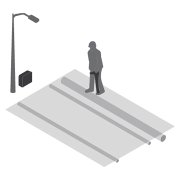 | 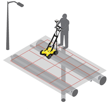 | 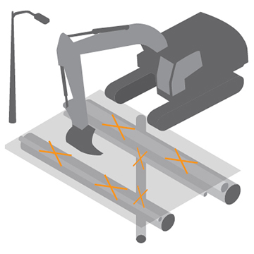 |
| STEP 1 : Collect information Start by collecting utility records from utility company or local municipality. Upload them into DXplore. If possible, go the site before the job to perform a visual inspection. Use an Electromagnetic Locator (EML) (hyperlink) to search for power cables and conductive utilities and mark them on the ground. | STEP 2: Map utilities with Leica DSX Set up the grid in the area of interest and collect information about all underground utilities with DSX and take advantage of automated and supported post-processing on site, resulting in a 3D utility map. DSX can be used together with Leica GPS/GNSS systems to generate highly accurate, georeferenced maps. Use additional information from STEP 1 in DXplore during data capture to support you in finalising the picture of the underground. | STEP 3: Excavate safely Mark out utilities in the field based on the map or, for even more efficiency, send the utility map directly to an excavator with Leica MC1 software or other Leica software suites such as DX Manager Mapping, Infinity, Captivate. For further processing and overlay with additional geospatial data. |
Hanya pelanggan yang sudah login dan telah membeli produk ini yang dapat memberikan ulasan.
Produk Terkait


Alpha D200 Ground Penetrating Radar
Baca selengkapnyaKey Features • Built-in 200MHz antenna • Compact, lightweight, low-power integrated design • Compatible with Windows and other platforms • Real-time acquisition software (SDI-GPR) and data processing tools • User-friendly interface for quick adoption • Large-capacity hard drive storage for easy data preservation Software Functions • Reference subtraction, filtering, background processing, auto-gain • Gain adjustment …

Kabel Locator Leica DD120
Baca selengkapnyaSimplifying Use Ease of Use – The locator requires minimal adjustment to locate services. Removing the sensitivity control also ensures detectable services cannot be missed where the user reduces sensitivity too much. In-built Self Test – A quick check can easily be performed by staff or users to ensure units are working correctly. This can …

Kabel Locator Alpha DT2
Baca selengkapnyaThe underground pipeline locator is the latest multifunctional equipment developed by AlphaGEO for detecting pipelines, pipes, cables, optical fibers, etc. It can accurately determine the position, path direction, and burial depth of underground pipelines. It can identify target cables even in complex cable networks and precisely locate cable grounding faults. As a comprehensive solution in …


Ulasan
Belum ada ulasan.