


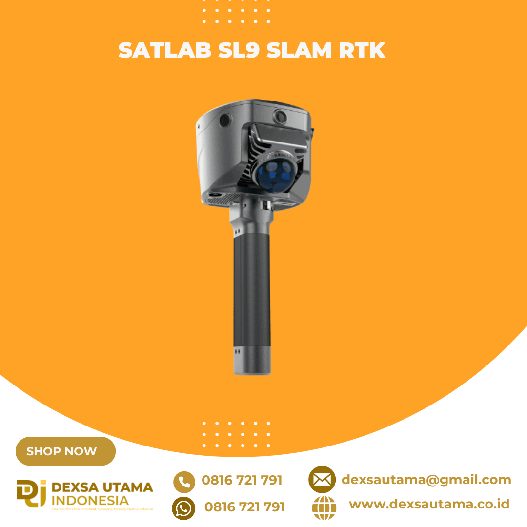
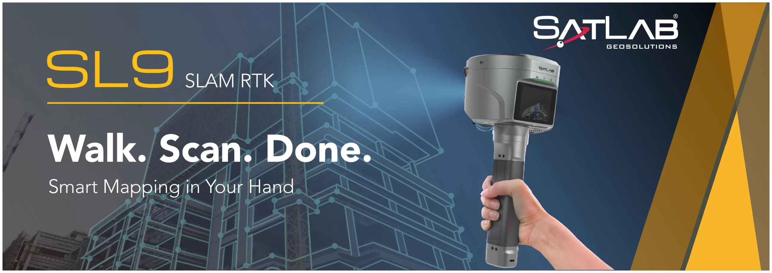
SatLab SL9 SLAM RTK
SatLab SL9 SLAM RTK combines high-precision GNSS positioning with cutting-edge SLAM technology, eliminating the spatial constraints of traditional RTK measurements. Whether in urban buildings, dense forests, or indoor environments, SL9 ensures reliable, precise measurements, redefining efficiency and versatility in fieldwork
1. New Image Measurement Experience
With three HD cameras and SLAM integration, the SL9 lets you measure in real-time—just select the target point in the image to get its 3D coordinates. Achieve 2–5 cm accuracy within 15 meters using the Satsurv app.
2. Boundaryless Surveying with SLAM-Fix Tech
SL9 smartly switches between RTK and SLAM. Get reliable coordinates even under bridges, eaves, or indoors—no signal, no problem.
3. Unified Coordinate System
No more stitching data. SL9 keeps your coordinates unified across environments—no control points, no loop closure, no hassle.
4. Fast & Easy Volume Calculation
Instantly generate 3D terrain and calculate volumes right on-site using the Android-based Satsurv app.
5. Reliable Signal, High-Quality Data
Track all major constellations with superior performance in tough environments, achieving centimeter-level accuracy.
6. Precision Post-Processing with Sat-LiDAR
Post-process your data with Sat-LiDAR for <2 cm thickness and <1 cm accuracy. The software supports tunnel excavation analysis, progress monitoring, and acceptance checks. It also aids renovation projects with cross-section, plan, and elevation outputs.
Video Player
Applications
- Semi-Open Environment Surveys
- 3D Facility Mapping
- Engineering Surveys

Brosure
Hanya pelanggan yang sudah login dan telah membeli produk ini yang dapat memberikan ulasan.
Produk Terkait


Laser Scanner Lixel L2
Baca selengkapnyaHandheld Real-Time 3D Reconstruction Laser Scanner Lixel L2: Teknologi Canggih untuk Scanner 3D Dalam dunia survei dan konstruksi, teknologi pemindaian 3D semakin berkembang pesat. Salah satu inovasi terbaru yang menarik perhatian adalah Laser Scanner Lixel L2, sebuah handheld real-time 3D reconstruction laser scanner yang mampu memberikan hasil pemindaian akurat dengan detail luar biasa. Apa saja …

LiDAR CHCNAV AlphaAir 10
Baca selengkapnyaThe AlphaAir 10 is a professional airborne LiDAR+RGB system designed to meet the demanding requirements of UAV LiDAR mapping and drone photogrammetry. This advanced solution integrates superior LiDAR technology with accurate GNSS positioning, IMU orientation, and a professional full frame orthophoto camera. Together with CHCNAV’s point cloud and image fusion modeling software, the AA10 delivers survey-grade accuracy, efficiency, and cost-effectiveness in 3D data acquisition and processing

Hitarget V700S SLAM RTK
Baca selengkapnyaHi-Target V700S SLAM RTK adalahperangkat GPS Geodetik inovatif yang menggabungkan teknologi Real-Time Kinematic (RTK) dan Simultaneous Localization and Mapping (SLAM). Perpaduan ini memungkinkan pengukuran dengan akurasi tingkat sentimeter, baik di area terbuka dengan sinyal GNSS kuat maupun di lokasi yang sulit dijangkau, seperti terowongan, lorong, atau di bawah jembatan

Laser Scanner Lixel K1
Baca selengkapnyaLaser Scanner Lixel K1 – Scanner 3D Genggam yang Ringkas & Presisi Lixel K1 adalah perangkat pemindaian dan pemodelan 3D Lidar genggam yang ringkas, ringan, dan mudah digunakan. Dengan berat hanya 1 kg, alat ini dirancang untuk kemudahan mobilitas dan efisiensi kerja. Fitur Unggulan Laser Scanner Lixel K1 Ringkas & Mudah Dibawa – Material aluminium …


Ulasan
Belum ada ulasan.