


Controller Alpha GEO S50III Android
Controller Alpha GEO S60III : Solusi Handheld Tangguh untuk Surveyor Profesional
Dalam dunia pengukuran dan pemetaan, keandalan perangkat adalah kunci utama untuk mendapatkan hasil yang presisi. S60III hadir sebagai data collector terbaru yang dirancang khusus untuk memenuhi kebutuhan surveyor dan profesional pemetaan. Dengan prosesor industri terbaru dari Qualcomm dan berbagai fitur unggulan, S60III siap memberikan pengalaman terbaik dalam pengumpulan data di lapangan.
Layar Tahan Banting, Tetap Jernih di Bawah Sinar Matahari
S60III dibekali layar 5.5 inci dengan tingkat kecerahan 500 nit yang didukung oleh Gorilla Glass. Hasilnya, layar ini tidak hanya tangguh terhadap goresan dan benturan tetapi juga tetap terlihat jelas meskipun digunakan di bawah sinar matahari langsung. Ini menjadi keunggulan utama bagi surveyor yang bekerja di medan terbuka dengan kondisi pencahayaan ekstrem.
Konektivitas Lengkap untuk Fleksibilitas Maksimal
Koneksi adalah aspek krusial dalam pengukuran GNSS dan RTK. S60III menawarkan berbagai opsi konektivitas, mulai dari Bluetooth 5.0, Wi-Fi dual-band (2.4G & 5G), hingga modem 4G yang mendukung jaringan global. Dengan dukungan ini, Anda dapat terhubung secara stabil ke receiver GNSS favorit Anda atau jaringan koreksi RTK untuk mendapatkan data yang lebih akurat.
Baterai 9000mAh: Tahan Seharian Tanpa Khawatir
Salah satu tantangan terbesar dalam penggunaan perangkat di lapangan adalah daya tahan baterai. S60III mengatasi masalah ini dengan baterai berkapasitas besar 9000mAh, yang memungkinkan penggunaan sepanjang hari tanpa perlu sering mengisi ulang daya. Dengan berat hanya 420 gram, perangkat ini tetap nyaman digunakan meskipun memiliki kapasitas baterai besar.
Tangguh di Segala Kondisi Lapangan
Bekerja di lingkungan ekstrem bukan masalah bagi S60III. Perangkat ini telah mengantongi sertifikasi IP68 yang menjadikannya tahan air dan debu. Ditambah lagi, S60III dirancang untuk bertahan saat terjatuh dari ketinggian hingga 1.5 meter, memastikan perangkat tetap berfungsi dengan baik meskipun menghadapi kondisi lapangan yang sulit.
Performa Tinggi untuk Produktivitas Maksimal
Ditenagai oleh prosesor Qualcomm 662 dengan fabrikasi 11nm, S60III menawarkan performa tinggi untuk menangani berbagai tugas, mulai dari pengelolaan gambar CAD hingga tampilan peta dasar secara real-time. Dengan sistem operasi Android 12 dan GMS Certification, perangkat ini juga mendukung berbagai aplikasi profesional yang membantu mempermudah pekerjaan surveyor.
Desain Ergonomis dengan Keyboard Fisik
Meski memiliki desain yang slim dan ringan, S60III tetap mempertahankan fitur keyboard fisik yang dioptimalkan untuk kemudahan input data. Dengan tata letak keyboard yang telah disempurnakan, pengguna dapat memasukkan data dengan cepat tanpa harus mengubah kebiasaan mereka. Selain itu, beberapa tombol pintas telah disematkan untuk mempercepat akses ke fungsi utama dalam aplikasi industri.
Specifications
| System | Operating system | Android 12 GMS support |
| CPU | Qualcomm SDM 662 octa-core 2.0 GHz | |
| RAM | 4 GB SDRAM | |
| Flash memory | 64 GB | |
| Memory card | MicroSDHC up to 128 GB | |
| Physical | Size(L × W × H) | 228 mm x 96 mm x 21 mm |
| Weight | 420 g (14.42 oz) with battery | |
| Environment | Operating: -20°C to +65 °C(-4°F to +149°F) | |
| Storage: -30°C to +70°C(-22°F to +158°F) | ||
| Dust and water proof | IP68 | |
| Humidity | 5%~95% (non-condensing) | |
| Shock and vibration | 1.2 m (4 ft) fall on concrete | |
| Display | 5.5″IPS LTPS LCD capacitive multi-touch 1920 x 1080 pixels HD+ 401 ppi Brightness 500 nit | |
| Keypad | QWERT KEY | |
| Communications | SIM Card Type | Nano-SlM card |
| Network modem | GSM: 850/900/1800/1900 | |
| WCDMA:B1/B2/B4/B5/B8 | ||
| LTE-TDD: B34/B38/B39/B40/B41 | ||
| LTE-FDD:B1/B2/B3/B4/B5/B7/B8/B12/B13/B17/B20/B25/B26/B28 | ||
| Wi-Fi | 802.11 a/b/g/n/ac access point mode (2.4 G/5G) | |
| Bluetooth | V5.0 | |
| USB | Type C, OTG supported | |
| NFC | Support | |
| Electrical | Li-ion battery capacity | 9000 mAh |
| Operating time(1) | 22 h | |
| Charging time | 4h(typical) | |
| Sensors and Multimedia | 13 MP rear camera with auto-focus and flash | |
| GNSS (BDS, GPS, GLONASS) | ||
| A-GPS support | ||
| G-sensor | ||
| Gyroscope | ||
| E-compass | ||
| Light sensor | ||
| Speaker | ||
| Microphone | ||
| Standard Accessories | A/C charger | |
| USB cable | ||
| Stylus | ||
| Handstrap | ||
| Field Software | ||
| Certifications | CE, FCC | |
Brosure
Kelengkapan
Hanya pelanggan yang sudah login dan telah membeli produk ini yang dapat memberikan ulasan.
Produk Terkait
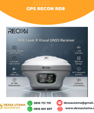

GPS Recon RD8
Baca selengkapnyaRECON RD8 Laser This tool is designed to increase the efficiency and accuracy of measurements in the field, especially in difficult conditions such as closed areas, tall objects, or locations that cannot be reached directly. With a combination of visual and laser technology, the RD8 enables non-contact measurements (without touching the object) and real-time target …


Ulasan
Belum ada ulasan.