


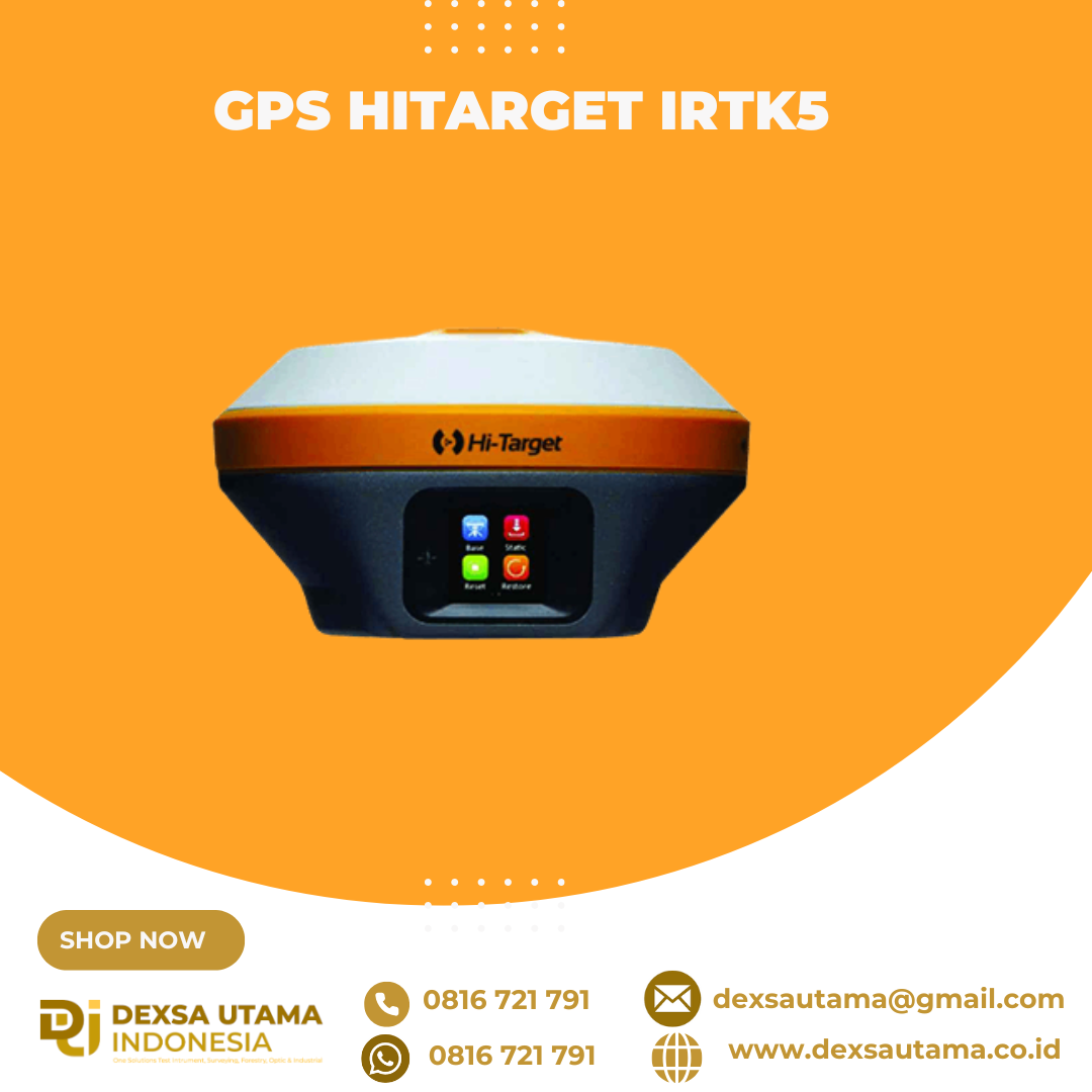
GPS Hitarget iRTK5
GPS geodetik berteknologi tinggi yang menawarkan solusi survei GNSS RTK (Global Navigation Satellite System Real-Time Kinematic) untuk kebutuhan pemetaan dan konstruksi. Alat ini didesain dengan mesin GNSS generasi terbaru dan teknologi komunikasi nirkabel untuk memberikan akurasi posisi tingkat sentimeter
Revolutionary Tilt Survey with Built-in IMU
Customers benefit from calibration-free for tilt surveys without centering. Once you reach the surveying points, immediately start the operation. Compared with bubble leveling, boost working efficiency by 20%.

Spesifikasi
Satellite Signals Tracked Simultaneously
- Channels: 1760
- GPS: L1C/A, L1C, L2P(Y), L2C, L5
- BDS: B1l, B2l, B3l, B1C, B2a, B2b
- GLONASS: L1, L2, L3
- Galileo: E1, E5a, E5b, E6
- QZSS: L1, L2, L5, L6*
- NavlC: L5
- SBAS: L1, L2, L5
- PPP: B2b-PPP, Galileo E6-HAS
POSITIONING PERFORMANCE
- High-Precision Static
- Horizontal: 2.5 mm + 0.1 ppm RMS
- Vertical: 3.5 mm + 0.4 ppm RMS
- Static and Fast Static
- Horizontal: 2.5 mm + 0.5 ppm RMS
- Vertical: 5 mm + 0.5 ppm RMS
- Post Processing Kinematic (PPK / Stop & Go)
- Horizontal: 8mm+1ppm RMS
- Vertical: 15mm+1ppm RMS
- Initialization time: Typically 10 min for base and 5 min for rover
- Initialization reliability: Typically > 99.9%
- Code Differential GNSS Positioning
- Horizontal: ±0.25m+1ppm RMS
- Vertical: ±0.5m+1ppm RMS
- SBAS: 0.5m(H), 0.85m(V)
- PPP: 10cm(H), 20cm(V)
- High-Precision Static
Real Time Kinematic (RTK)
- Single Baseline
- Horizontal: 8mm+1ppm RMS
- Vertical: 15mm+1ppm RMS
- Network RTK(VRS,FKP,MAC)
- Horizontal: 8mm+0.5ppm RMS
- Vertical: 15mm+0.5ppm RMS
- Positioning rate: 1 Hz, 5 Hz and 10 Hz
- Initialization time: Typically 2-10s
- Initialization reliability: Typically>99.99%
- Hi-Fix
- Horizontal: RTK + 10 mm/minute RMS
- Vertical: RTK + 20 mm/minute RMS
- Tilt Survey Performance
- Additional horizontal pole-tilt uncertainty typically less than 8 mm +0.7 mm / °tilt (0° ~ 60°)
- Single Baseline
HARDWARE
- Physical
- Dimensions (W x H): 158mm x 98mm (6.22inch x 3.86inch)
- Weight: lighter than 1.3kg (2.65lb) within internal battery
- Operation temperature: -40°C~+75°C(-40°F~+167°F)
- Storage temperature: -50°C~+85°C(-58°F~+185°F)
- Temperature control: Auto-adjust the working power to maintain the temperature
- Humidity: 100%, condensing
- Water/dustproof: IP67 dustproof, protected from temporary immersion to depth of 1m (3.28ft)
- Shock and vibration: MIL-STD-810G, 514.6
- Anti-salt spray: MIL-STD-810G, 509.4, 96h
- Free fall: MIL-STD-810G, 516.6, designed to survive a 2m(6.56ft) natural fall onto concrete
- Electrical
- 6V to 28V DC external power input(5-pin port), with over-discharge protection power consumption 4.4W Automatic switching between internal power and external power
- Control Panel
- Physical button: 1
- Display: 1.3″ OLED Touch Screen
- LED Lights: Satellite, Signal, Power
- Battery
- 2 V, 6900 mAh lithium-ion rechargeable and removable battery.
- RTK rover(UHF/Cellular) for 24 hours.
- Power indicator embedded.
- Quick charge within 3.5 hours.
- I/O Interface
- Bluetooth 4.0/2.1+ EDR, 2.4 GHz. USB 3.0 port , OTG function. 1 SMA antenna connector.
- 1 DC power input(5-pin),1 SIM card slot.
- Near Field Communication(NFC)
- Physical
Communication
- Network Communication
- Full band support for cellular mobile network(LTE, WCDMA, EDGE, GPRS, GSM). 2.4GHz Wi-Fi, supports the standard protocol 802.11 b/g/n. Network RTK(in CORS) range is 20-50km.
- Internal UHF Transceiver Radio
- Frequency: 403~473MHz
- Transmitting power: 1~5W Hi-Target Advanced Radio Supports protocols: HI-TARGET, TRIMTALK450S, TRIMMARK III, SATEL-3AS, TRANSEOT, etc.
- Working Range: Typically 3~5km, optimal 8~15km
- External UHF Radio
- Frequency: 403~473MHz
- Transmitting power: 10W / 35W
- Compatible with third party radio Working Range: Typically 8~10km, optimal 15~20km
- SYSTEM CONFIGURATION
- System Data storage: Circulating 16GB Internal storage Record GNS and RINEX format simultaneously
- Data Formats
- Output rate: 1Hz-20Hz
- Static data format: GNS, Rinex Dual Format Static Data
- Network model: VRS, FKP, MAC; supports NTRIP protocol
- CMR & RTCM: RTCM2.X, RTCM3.X, CMR
- Navigation outputs ASCI: NMEA-0183
- Network Communication
Brosure
Video
Video Drone DJI & GPS Hi-Target iRTK5
Hanya pelanggan yang sudah login dan telah membeli produk ini yang dapat memberikan ulasan.
Produk Terkait


CHCNAV HCE600
Baca selengkapnyaThe HCE600 is a lightweight, professional Android data collector designed for field surveying and mapping. With a 5.5-inch DragonTrail™ display, it offers exceptional durability and clear visibility in sunlight. Packed with Bluetooth 5.0, dual-band Wi-Fi, and a 4G modem, it ensures seamless connectivity with GNSS receivers and RTK networks. Certified to IP67 and MIL-STD-810H standards, the HCE600 is built to withstand harsh environments, making it the ideal handheld controller for reliable data collection in any conditions


Ulasan
Belum ada ulasan.