Depan
Menampilkan 91–120 dari 909 hasilDiurutkan menurut yang terbaru
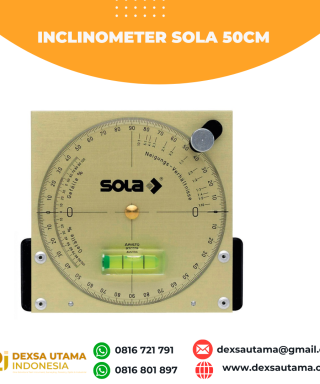

Inclinometer Sola 50cm
Baca selengkapnyaThe Sola magnetic inclinometer for use on drill rigs on drilling sites, geological surveys and mineral exploration projects. The instrument attaches to a drill rig mast via a strong magnet and provides users with the orientation and angle of drilling a bore hole or extracting core samples. The face 12 cm in diameter with black print for easy reading against the brass background and a spirit level for accuracy

Inclinometer Sola 13cm
Baca selengkapnyaThe Sola magnetic inclinometer for use on drill rigs on drilling sites, geological surveys and mineral exploration projects. The instrument attaches to a drill rig mast via a strong magnet and provides users with the orientation and angle of drilling a bore hole or extracting core samples. The face 12 cm in diameter with black print for easy reading against the brass background and a spirit level for accuracy

GPS Geodetik RTK Comnav Sino Jupiter Laser
Baca selengkapnyaChannel 1668 Satellites tracking GPS: L1C/A, L1C, L2P, L2C, L5 BDS: B1l, B2l, B3l, B1C, B2a, B2b GLONASS: L1, L2, L3 Galileo: E1, E5a, E5b, E6c, E5 AItBOC QZSS: L1C/A, L2C, L5, L1C IRNSS: L5 SBAS: L1C/A PPP: B2b & HAS L-Band Signal Re-acquisition ≤1s Cold Start ≤30s Hot start ≤10s RTK Initialization Time <5s(Baseline≤10km) …

GPS Comnav Sino Mars Pro Laser
Baca selengkapnyaThe Mars Pro is an ultra-reliable GNSS receiver with a millimeter-level laser, enabling it to handle complex surveying tasks with unmatched precision, for example, in hard-to-reach, signal-obstructed, and dangerous fields. Mars Pro also features a sunlight-readable OLED color display for user-friendly, high-end operations. Breaking the usual constraints in land surveying, construction, and GIS, it is the go-to choice for professionals looking to elevate their work.- 1668 channels and 60+ satellites tracking capabilities
- Tracking all running and planned constellations, including GPS, BDS-2, BDS-3, GLONASS, Galileo, QZSS, IRNSS, and SBAS
- Up to 120° tilt with 2.5 cm accuracy
- IP67 dust- and waterproof for harsh environments
- Up to 20 hrs non-stop use
- Enabling broader use through extensive protocol support, including Transparent/TT450S/SATEL/Trimtakl3/CHC/South

GPS Geodetik RTK Comnav Sino N2
Baca selengkapnyaSlim-line design makes the N2 one of the most compact GNSS receiver: only 48mm and 0.67kg including battery. Compared with a typical GNSS receiver, it is more than 35% thinner and 40% lighter, can be carried, used and operated more easily without fatigue. Lighter, Thinner, and Stronger – N2 is specifically designed for land survey, marine, precision agriculture, machine control, and GIS.- 1590 channels and 50+ satellites tracking capabilities
- Tracking all running and planned constellations, including GPS, BDS-2, BDS-3, GLONASS, Galileo, QZSS, IRNSS and SBAS
- Up to 15km work range with enhanced UHF
- Up to 120° tilt with 2.5 cm accuracy
- 20+ hrs continuous work with 10000mAh batteries
- Support NFC and Bluetooth connection
- IP67 dust- and waterproof for harsh environments

DJI Mavic 3 Multispectral
Baca selengkapnya- Effective aerial surveying needs to see the invisible. That’s why Mavic 3 Multispectral has two forms of sight. It combines an RGB camera with a multispectral camera to scan and analyze crop growth with total clarity. Agricultural production management requires precision and data, and Mavic 3M delivers both.

DJI Zenmuse L2
Baca selengkapnyaZenmuse L2 integrates frame LiDAR, a self-developed high-accuracy IMU system, and a 4/3 CMOS RGB mapping camera, providing DJI flight platforms with more precise, efficient, and reliable geospatial data acquisition. When used with DJI Terra, it delivers a turnkey solution for 3D data collection and high-accuracy post-processing.
DJI Zenmuse L1
Baca selengkapnyaDetection Range450 m @ 80% reflectivity, 0 klx ;
190 m @ 10% reflectivity, 100 klxPoint RateSingle return: max. 240,000 pts/s ;
Multiple return: max. 480,000 pts/sSystem Accuracy(RMS 1σ)1Horizontal: 10 cm @ 50 m;
Vertical: 5 cm @ 50 mReal-time Point Cloud Coloring ModesReflectivity, Height, Distance, RGB
DJI Matrice 350 RTK
Baca selengkapnyaAn upgraded flagship drone platform, the Matrice 350 RTK sets a new benchmark for the industry. This next-generation drone platform features an all-new video transmission system and control experience, a more efficient battery system, and more comprehensive safety features, as well as robust payload and expansion capabilities. It is fully powered to inject innovative strength into any aerial operation

DJI D-RTK 2 GNSS Mobile Station
Baca selengkapnyaWorks with Phantom 4 RTK & MG-1P RTK
Centimeter-Level Mapping Precision
Accesses GPS, GLONASS, Beidou & GALILEO
Connects via 4G, OcuSync, Wi-Fi & LAN
Connect up to 5 Remote Controllers
Carbon Fiber Body
IP67-Rated Water & Dust Resistance
Built-In IMUs Monitor Movement
IMUs Alert Operators of Abnormalities
DJI Matrice 4 Enterprise
Baca selengkapnyaIntroducing the DJI Matrice 4 Series, a new compact and intelligent multi-sensor flagship drone series for enterprise industries. The series includes Matrice 4T and Matrice 4E, each equipped with advanced features such as smart detection and measurement with laser range finder. Flight operations are now safer and more reliable with significantly enhanced sensing capabilities. The accessories for the Matrice 4 series have also been significantly upgraded. The Matrice 4T is suitable for a wide range of industries, including electricity, emergency response, public safety, and forestry conservation. The Matrice 4E is designed for geospatial applications such as surveying and mapping, construction, and mining. A new era in intelligent aerial operations begins now.
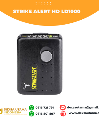
Strike Alert HD LD1000 Lightning Detector
Baca selengkapnyaLightning kills more people on an annual basis than tornadoes, hurricanes or winter storms – so play it safe outdoors! Whether you’re on the golf course, hiking or biking, or the kids are on the soccer field, use a StrikeAlert personal lightning detector to give you an early warning of the storm.
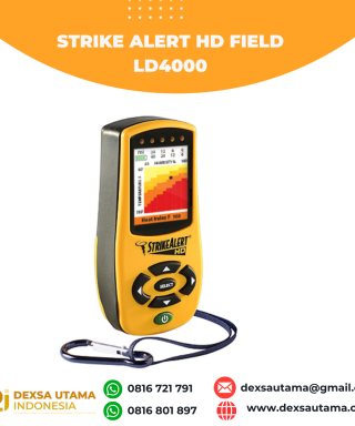
Strike Alert HD Field LD4000 Lightning Detector with Heat Index
Baca selengkapnyaLightning kills more people on an annual basis than tornadoes, hurricanes or winter storms – so play it safe outdoors! Whether you’re on the golf course, hiking or biking, or the kids are on the soccer field, use a StrikeAlert personal lightning detector to give you an early warning of the storm.

Nikon XS1
Baca selengkapnya- Hot swappable batteries that have the power to last all day, and then some.
- Superior Nikon optics and autofocus for crisp, bright sightings even in low light conditions.
- A full range of accuracies to ensure you have exactly the equipment you need for the work you do.
- PIN security to prevent unauthorized use.
- 800m non-prism EDM
- Autofocus
- Dual-face displays
- Fast, powerful EDM PIN security
- 1″, 2″, 3″, and 5″ accuracies
- Nikon onboard software
- Hot swappable batteries

Kestrel 5400FW Fire Weather Meter Pro with LiNK (salin)
Baca selengkapnyaThe Kestrel 5400 Fire Weather Pro provides Wet Bulb Globe Temperature (WBGT) monitoring and displays thermal work limit (TWL), a recognized composite heat stress prediction tool. Lightweight and easy to use, the unit offers quick set-up with the included vane mount and LiNK wireless connectvity to become a complete weather station capable of logging weather conditions and critical heat safety information.

Kestrel 5400 Heat Stress Trackers
Baca selengkapnyaEspecially made for athletics, construction, law enforcement and outdoor event organizers, the Kestrel 5400 series detects when heat-related conditions become unsafe before your body does. Measures 15 parameters in all including Wet Bulb Globe Temperature, Heat Index and more