Produk yang sudah dilihat
-

 Lutron VB-8220 Vibration Meter
 -
 South Baterai NB30A Rp0 + PPN 11%

Sanding Arc5 pro
- Garansi 1 Tahun
- Sertifikat Kalibrasi
- Layar 2 Dipslay
- Akurasi 2″
FEATURES

DISTANCE MEASUREMENT
1000m reflectorless measuring range covers a most common scale in your field job. With a single prism, you can reach up to 5km quickly with 2mm+2ppm accuracy.

DATA EXCHANGE
With flashdrive port, users can export/import data more easily and directly. New Arc5 pro support max.256G USB storage.

ANGLE MEASUREMENT
Arc 5 Pro adopts an absolute encoding system, which does not require initialization by 0 set, and delivers a precise and stable angle measurement with up to 2″ accuracy.

SOFTWARE: SANDING PC TOOL
Powerful and convenient data transfer and post processing software with concise and clear interface and user-friendly operation. User can download and upload raw data or coordinates in GSI format, edit coordinates and codes, design and edit road data, transfer GSI data to DXF file for processing in CAD, etc.

TILT COMPENSATOR
The dual-axis tilt compensator monitors the inclination of both X and Y axes, and then correct the horizontal and vertical angle reading automatically.

ON-BOARD SOFTWARE & APPLICATIONS
Arc 5 is powered by a sophisticated on-board software which enables you to manipulate the total station effectively, like setting the compensation, COGO, data viewing and transfer, calibration, etc.

DISPLAY & TRIGGER KEY
A high definition graphic display with 8 lines and 2 sides of alphanumeric keyboards provides clear images and convenient operation, A global key allows you take measure in any screen.

Brosur
Kelengkapan
• 1 unit Total Station Sanding Arc 5 pro
• 1 unit Batterai
• 1 unit Charger
• 1 unit Prisma Single
• 1 unit Prisma Polygon
• 1 unit Pole / Stick Prisma
• 2 unit Alumunium Tripod
• 1 Lembar Sertifikat Kalibrasi
• 1 Lembar Garansi 1tahun
SPECIFICATIONS
| TELESCOPE | |
| Tube Length | 154mm |
| Objective Lens Diameter | Telescope: 45mm; EDM: 50mm |
| Magnification | 30X |
| Image | Erect |
| Field of View | 1°30’ |
| Resolving Power | 3” |
| Min. Focus | 1.0m |
| DISTANCE MEASUREMENT | |
| Single Prism | 5000m *1 |
| Non-Prism | 1000m*2 |
| Accuracy -Prism Mode | ±(2mm+2ppm x D)m.s.e. *3 |
| -Non-Prism Mode | 0-300m:±(3mm+2ppm x D)m.s.e. *3 |
| 300m-600m: ±(5mm+3ppm x D)m.s.e. *3 | |
| Measuring time | fine: 0.3s; tracking: 0.1s *4 |
| Atmospheric Correction | T-P Sensor, Auto Detect and Correct |
| Prism Constant | Manual Input, Auto Correction |
| ANGLE MEASUREMENT | |
| Method | Absolute Encoding |
| Detecting System | H: 2 sides V: 2 sides |
| Min Reading | 0.5”/1”/5”10” selectable |
| Accuracy | 2” |
| Diameter of Circle | 79mm |
| Vertical Angle 0° | Zenith: 0°/Horizontal:0° |
| Unit | 360°/400gon/6400mil |
| DISPLAY | |
| Size | 3.5”; 320*240 Dot Matrix |
| No.of Display | 2 Color Screens |
| Keyboard | Alphanumeric |
| TILT CORRECTION | |
| Tilt Sensor | Dual Axis |
| Method | Liquid Electric |
| Range | ±3′ |
| Setting Unit | 1” |
| LEVEL SENSITIVITY | |
| Plate Level | 30”/2mm |
| circular vial | 8’/2mm |
| OPTICAL PLUMMET(OPTIONAL:INTERNAL LASER PLUMMET) | |
| Image | Erect |
| Magnification | 3X |
| Focusing Range | 0.3m ~ ∞ |
| Field of View | 5° |
| DATA STORAGE INTERFACE | |
| Storage | Internal Memory: 4MB; Max.SD card:32GB |
| Data Interface | SD-card/Mini USB/RS232C |
| GENERAL | |
| Laser Class *5 -EDM | Class IIIA |
| -Laser Plummet | Class II |
| Working Temperature | -20°C~ + 50°C |
| Battery Type | Rechargeable Lithium Battery |
| Battery Voltage | DC 7.4V |
| Working Time | 8h |
| Water & Dust Proof | IP55 |
Hanya pelanggan yang sudah login dan telah membeli produk ini yang dapat memberikan ulasan.
Produk Terkait

Nikon Nivo M
Rp0 + PPN 11%Tambah ke keranjangChoice of accuracy and plummet Reflectorless range up to 1,640 feet Range up to 16,404 feet with a single prism Integrated Bluetooth Built-in Nikon Survey software 50,000 points internal memory Optical plummet Optional laser plummet Coaxial red laser pointer Reflectorless and prism measurements Dual-axis compensation High-quality Nikon optics Up to 62 hours interchangeable batteries Water resistant and …

Sanding ARC 1
Baca selengkapnyaBringing excellent efficiency to your field tasks! ARC1 is an all-in-one professional Robotic Total Station with ARCSURV software, APR & LocknTRack for easy prism tracking. It works with GNSS, enables automatic monitoring, and delivers reliable results in all conditions.

Nikon XS5
Baca selengkapnya- Hot swappable batteries that have the power to last all day, and then some.
- Superior Nikon optics and autofocus for crisp, bright sightings even in low light conditions.
- A full range of accuracies to ensure you have exactly the equipment you need for the work you do.
- PIN security to prevent unauthorized use.
- 800m non-prism EDM
- Autofocus
- Dual-face displays
- Fast, powerful EDM PIN security
- 1″, 2″, 3″, and 5″ accuracies
- Nikon onboard software
- Hot swappable batteries

Hitarget HTS−521 L10 Total Station
Baca selengkapnyaHD Color Screen Long Range Total Station
HTS-521L10 adopts a high-definition color screen to provide better human-computer interaction. The new optical design and absolute coding technology improve the measurement performance. High-precision compact bead shafting and sealed encoder disk enhance accuracy and stability. Built-in abundant measurement programs and comprehensive maintenance procedures will provide a new measurement experience.

Nikon XS2
Baca selengkapnya- Hot swappable batteries that have the power to last all day, and then some.
- Superior Nikon optics and autofocus for crisp, bright sightings even in low light conditions.
- A full range of accuracies to ensure you have exactly the equipment you need for the work you do.
- PIN security to prevent unauthorized use.
- 800m non-prism EDM
- Autofocus
- Dual-face displays
- Fast, powerful EDM PIN security
- 1″, 2″, 3″, and 5″ accuracies
- Nikon onboard software
- Hot swappable batteries
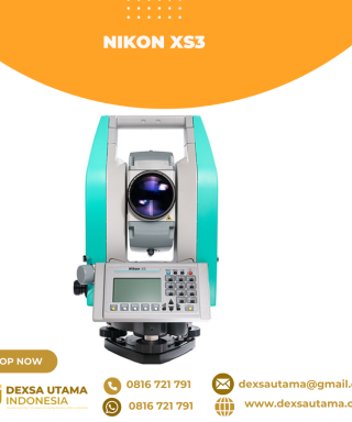
Nikon XS3
Baca selengkapnya- Hot swappable batteries that have the power to last all day, and then some.
- Superior Nikon optics and autofocus for crisp, bright sightings even in low light conditions.
- A full range of accuracies to ensure you have exactly the equipment you need for the work you do.
- PIN security to prevent unauthorized use.
- 800m non-prism EDM
- Autofocus
- Dual-face displays
- Fast, powerful EDM PIN security
- 1″, 2″, 3″, and 5″ accuracies
- Nikon onboard software
- Hot swappable batteries

Total Station Hitarget HTS-720
Baca selengkapnya5.5-inch Display, Endless Versatility The HD screen delivers a true color display, great for viewing and fulfilling tasks. Adaptive brightness adjustment and half-sided screen operation setting for versatile workflow in any light conditions and single task. 8MP Camera, Visual Guidance HTS-720 features an HD camera with an 8MP sensor, perfect for recording points in …

Robotic Total Station ALPHA R1
Baca selengkapnyaAutomatic Prism Recognition (APR) •Automatically identifies and measures prisms at distances up to 1000m •Ensures precise target acquisition without manual intervention Intelligent Prism Search •Performs 360° prism detection within a 300m radius •Reduces measurement steps by approximately 67% compared to manual total stations •Significantly enhances field work efficiency. Continuous Prism Tracking •Maintains lock on moving …

Total Station Alpha X
Baca selengkapnyaTotal Station ALPHA X dengan Surpro 6.0 untuk Proyek Teknik ALPHA X adalah Total Station generasi terbaru dengan desain kompak, dilengkapi kompensator dua sumbu (Dual-axis compensator), keyboard alfanumerik, serta layar LCD 6 baris x 20 karakter. Dengan tambahan tombol trigger, proses pengukuran menjadi lebih mudah dan cepat. Dilengkapi bluetooth bawaan, ALPHA X memungkinkan koneksi dengan …

Nikon XS1
Baca selengkapnya- Hot swappable batteries that have the power to last all day, and then some.
- Superior Nikon optics and autofocus for crisp, bright sightings even in low light conditions.
- A full range of accuracies to ensure you have exactly the equipment you need for the work you do.
- PIN security to prevent unauthorized use.
- 800m non-prism EDM
- Autofocus
- Dual-face displays
- Fast, powerful EDM PIN security
- 1″, 2″, 3″, and 5″ accuracies
- Nikon onboard software
- Hot swappable batteries

CHCNAV CTS-A100 Total Station
Baca selengkapnyaThe CTS-A100 is a reflectorless total station optimized for efficient fieldwork, featuring the Android OS and CHCNAV’s LandStar software for intuitive, high-performance surveying. Its powerful EDM system offers a range of 5000 m with a prism and 1500 m without a reflector. Its built-in Qualcomm octa-core processor ensures smooth operation. The CTS-A100 is perfect for everyday surveying tasks such as construction layout and topographic mapping, providing accurate and reliable data collection.

SatLab SLT12 Android Total Station
Baca selengkapnyaBoasting an integrated Android operating system and specialized Android software, SLT12 seamlessly integrates cutting-edge technology into every measurement task. The two high-definition touch displays elevate operational fluidity, while the built-in camera enables AR stakeout effortlessly, making SLT12 an indispensable tool for optimizing workflows and achieving exceptional results


Invoice & Faktur Pajak

Dexsa Utama akan menerbitkan Kwitansi, Invoice, Faktur Pajak , Surat Jalan dan dikirimkan bersama Barang Pesanan.
Transaksi 100% Aman
Dexsa Utama menghadirkan pilihan metode pembayaran yang aman dan nyaman Melalui Rekening Perusahaan
Garansi & Jaminan Keaslian
Dexsa Utama menjamin produk yang kami jual 100% original berkualitas & Bergaransi
Populer
-

 Rotating Levelling Laser AL-HVG Green
 -
 Pentax Baterai BP02C Rp0 + PPN 11%
Ulasan
Belum ada ulasan.