Produk yang sudah dilihat


GPS GINTEC G40+
G40Plus is the latest masterpiece of the Gintec team in 2024, a super RTK (Real-Time Kinematic) system that focuses on high-performance radio communication. G40Plus not only inherits all the advantages of the G40 base unit but also expands the power and range of the radio communication. It can cover a maximum distance of 20km, and in urban areas, it has been tested to reach nearly 14km. It boasts an exceptional battery life, with a continuous working time of up to 8-10 hours in the 5W power base station mode. It features an upgraded night vision starlight camera that can operate effectively in low-light conditions…
There are more features waiting for you to explore!
Spesifikasi
Super Base
Equipped with 5W high power internal radio, radio signal covers up to 20 km.
High-Capacity Built-in Battery, Longer Duration
13600mAh large capacity built-in battery, the operation duration is up to 8-10 hours(Base mode, 5W power)
New-Generation SoC
Powerful GNSS SoC chip with 1408 channels
Supporting the new B1C, B2a, B2b, and BeiDou-3
G-FIX supported
Calibration-Free Tilt Compensation
Calibration and initialization FREE
Ready for tilt survey straight out of the box
G-FIX Correction Outage Technology
Extending RTK positioning up to 10mins
Reducing downtime waiting to re-establish RTK corrections
New Antenna Combination
Highly integrated GNSS,4G, WIFI, and Bluetooth antennas
Powerful Performance. Smaller Size
Anti-Interference Technology
Advanced multi-frequency interference suppression and multi-step adaptive filtering technology
Strong and stable signals in challenging conditions
Augmented Reality (AR)
Overlaying digital information onto the real world
Assisting to view the stakeout location and see designed features in real time
Professional Camera
High-resolution Night vision camera
Broad perspective, sophisticated algorithms guaranteeing the precision up to 1cm
Seamlessly combining 360-degree AR layout and image layout
G-FIX Correction Outage Technology
G-FIX Correction Outage Technology refers to the use of methods and techniques to mitigate the effects of GNSS correction data loss or outage,which is used to improve the accuracy of positioning by correcting errors caused by atmospheric and other environmental factors.
Widely used in
Surveying and Mapping / Geographic Information System / Agriculture / Aerospace / Oceanography and hydrology / Road and transportation / Construction
Brand-New Calibration and initialization FREE IMU
By utilizing a highly accurate Inertial Measurement Unit (IMU) and a unique tilt compensation function, RTK tilt measurement has been made practical.
No calibration required, GINTEC G40 RTK is ready for precise measurement from the moment when it is turned on, allowing instant use.
It is resistant to magnetic interference, making it suitable for use in any location.
RTK measurement is no longer bound by bubbles, realizing an efficiency improvement of at least 30%, and greater measurement accuracy is guaranteed.
AR Stakeout
Use an AR tool to visualize the location and position of a design feature or structure on a real-world site.This involves using a GNSS receiver to locate the position of the design feature or structure on the site, and then overlaying an augmented reality image of the feature onto the real-world view.This process helps the surveyors to accurately stake out the location of the feature or structure and ensure that it is built according to the design specifications.
Brosur
Hanya pelanggan yang sudah login dan telah membeli produk ini yang dapat memberikan ulasan.
Produk Terkait


Kontroler Hitarget iHand55
Baca selengkapnyaThe iHand55 Handheld Controller is a professional field controller with a big vision. Adopting a full-keyboard design, iHand55 supports the fast charge. The updated screen is readable in direct sunlight. More features of the latest Hi-Survey Road Software contribute to achieving high intelligence. Keeping robust and reliable in fieldwork under any conditions, iHand55 is a perfect choice for your survey work

SatLab Eyr GNSS
Baca selengkapnyaEquipped with dual cameras, the Eyr features image measurement and visual stakeout, which not only provide a wide range of contact-free measurement solutions but also make stakeout operations intuitive and simple. The design of the RTK is aesthetic but practical, and the pocket-sized and lightweight body makes it portable and versatile.

GPS Sanding T9
Baca selengkapnyaMore information Distinguishable features MDS Internal radio adopts TRIMTALK protocol which enables T9 to work with other receives with same protocol. Power Operating power: min. [V] 7.4 Operating power: max. [V] 7.4 Typical consumption [W] 2 Internal power supply Removable 7.4V, 2500mAh Li-on battery External power supply 12-15V DC Operating time with internal power supply …

GPS GNSS Alpha Geo Matrix II AR + Laser
Baca selengkapnyaGNSS Alpha GEO Matrix II AR + Smart Laser Teknologi Canggih untuk Pengukuran yang Lebih Akurat dan Efisien AR – Stakeout Jadi Lebih Mudah dan Akurat GNSS Alpha Geo Matrix II Dengan fitur Augmented Reality (AR), Matrix II memungkinkan surveyor menandai titik langsung di lapangan tanpa perlu menggeser pole berulang kali. Cukup ikuti arah panah …
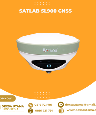
SatLab SL900 GNSS
Baca selengkapnyaThe SatLab GNSS receiver is a high-precision that performs even under the most demanding conditions. With this GNSS receiver, it is capable of delivering highly accurate GPS data in real-time to any device via a Bluetooth connection. Satellite correction service, compact and lightweight, this rtk GNSS is one of the most flexible solutions that promise positioning reliability.

GPS EFIX C8
Baca selengkapnyaThe EFIX C8 is a groundbreaking surveying RTK that seamlessly combines state-of-the-art vision, GNSS and IMU technologies. By integrating a powerful vision system, the C8 revolutionizes surveying workflows, streamlining operations, and delivering superior results in every surveying project. This integration empowers surveyors to tackle complex surveying tasks with unprecedented accuracy and ease. The real-time visual feedback provided by the vision system enables accurate stakeout, eliminating the need for complicated offset methods. Surveyors can efficiently measure previously inaccessible points and streamline their surveying workflow, increasing overall productivity. With the EFIX C8, surveyors can enhance their surveying capabilities and achieve superior results on every project they undertake.

GPS EFIX F8
Baca selengkapnyaThe EFIX F8 seamlessly integrates cutting edge VISION, GNSS and IMU technologies to meet the needs of professional surveyors. It offers unparalleled accuracy and efficiency for surveying tasks.With the integration of dual cameras, the F8’s advanced vision system allows surveyors to effortlessly overcome obstacles and survey challenging terrain, including difficult-to-fix, hard-to-reach, and hazardous points. Real-time visual feedback enables precise stakeout without the complexity of offset methods, resulting in improved efficiency and accuracy.By leveraging the capabilities of the F8, surveyors can streamline their workflow, increase productivity and achieve exceptional results in every project they undertake.
Kcosit Windows 10 With Magnet Field Sokkia
Rp0 + PPN 11%Tambah ke keranjangIP67 Waterproof Shockproof Dustproof Windows 10 IOT Enterprise Intel CPU Quad-Core Cherry Trail Z8350 6″ 1280X720 Pixel IPS 4GB RAM+64GB ROM Dual Camera 5.0MP Back+ 2.0MP Front Battery Capacity: 5000mAH Built-in 3G, Wifi ,GPS, Bluetooth Sim Card Quantity: Single SIM

GPS GNSS Alpha Geo Matrix VI
Baca selengkapnyaGNSS Alpha Geo Matrix VI dengan Teknologi Visual, AR, dan Laser untuk Pengukuran yang Lebih Presisi Mengukur Seakurat Mata Sendiri GNSS Alpha Geo Matrix VI adalah receiver GNSS kelas survey yang menggabungkan teknologi Visual Positioning, algoritma fotogrametri, serta fitur AR dan laser untuk meningkatkan produktivitas surveyor—baik profesional maupun pemula. Dengan perangkat ini, titik-titik yang sebelumnya …

GPS CHCNAV i89
Baca selengkapnyaThe i89 is a compact yet powerful surveying tool with a 1408-channel GNSS module that enhances RTK performance in challenging conditions. Its advanced ionospheric modeling ensures reliable RTK fixes, even during high solar activity. With 16.5 hours of battery life and a lightweight 750 g design, the i89 delivers efficiency and ease for daily surveying tasks.

Controller Alpha GEO S50III Android
Baca selengkapnyaController Alpha GEO S60III : Solusi Handheld Tangguh untuk Surveyor Profesional Dalam dunia pengukuran dan pemetaan, keandalan perangkat adalah kunci utama untuk mendapatkan hasil yang presisi. S60III hadir sebagai data collector terbaru yang dirancang khusus untuk memenuhi kebutuhan surveyor dan profesional pemetaan. Dengan prosesor industri terbaru dari Qualcomm dan berbagai fitur unggulan, S60III siap memberikan …

GPS GINTEC G20
Baca selengkapnyaSystem
Bluetooth V2.1+EDR / V4.0 dual mode
WIFI 802.11 b/g/n
Radio External:5W/35W Internal:0.5W/1W(can be adjusted)
Frequency:410~470MHZ
Protocol:TrimTalk,TrimMark3,SOUTH,PCC-EOT
Network LTE FDD: B1/B3/B5/B8 LTE TDD: B38/B39/B40/B41 TD-SCDMA: B34/B39 CDMA: BC0 WCDMA: B1/B8 GSM: 900/1800MHz
GPS SINGULAR XYZ X1
Baca selengkapnyaThe SingularXYZ X1 GNSS Receiver is a lightweight, ultra-compact RTK receiver designed for demanding field conditions. Offering full satellite tracking, tilt compensation, and a long-lasting battery, it delivers consistent high-precision results in any environment.

SatLab SL8 Laser GNSS
Baca selengkapnyaSatLab SL8 Laser RTK combines dual cameras, GNSS, IMU,and visible laser technology to make surveying faster and easier. With non-contact measurement, image-assisted targeting, CAD live-view stakeout, and a built-in LoRa radio,It ensures smooth, reliable work even in complex or GNSS-limited environments.

ESurvey E600
Baca selengkapnyaThe new e-survey E600 GNSS Receiver is coming to change the scene in the high-end GNSS receiver market. With up to 800 true channels and surprising performance, it is destined to be the perfect ally of the topographer – and not only – in the pursuit of perfection. E600 supports all the new technologies (Tilt …

CHCNAV DL8 Radio External
Baca selengkapnyaThe DL8 UHF radio modem provides reliable base-to-rover GNSS RTK corrections over long distances. Designed for harsh environments, it supports up to 28 W of adjustable output power, ensuring robust communication even in challenging conditions. With customizable frequency channels and a rugged IP67-rated enclosure, the DL8 is an essential tool for surveyors requiring dependable and high-performance data links.

GPS Hitarget V30 Plus Rover
Baca selengkapnyaHi-Target V30 Plus adalah
sistem Global Navigation Satellite System (GNSS) RTK (Real-Time Kinematic) geodetik, yang dirancang untuk survei dan pemetaan dengan presisi tinggi. Perangkat ini memiliki desain kokoh berkelas industri yang ringkas, dengan mesin GNSS multi-konstelasi untuk pemosisian yang stabil dan akurat bahkan di lingkungan yang sulit.
GPS TOKNAV T10 PRO
Rp0 + PPN 11%Tambah ke keranjangCharacteristic Linux Intelligent System Qualcomm Cortex-A7 + Linux, the intelligent system platform, brings efficient computing and unlimited expansion of product functions to users. Multi Constellation With its 1408 channels, T10Pro provides an excellent on board real time navigation solution with high accuracy. All GNSS signals (GPS, GLONASS, BDS, GALILEO, QZSS, SBAS and IRNSS) are included. …

GPS EFIX C5
Baca selengkapnyaC5 GNSS Receiver
100% MORE EFFICIENT TO DO SURVEYING AND STAKING-OUT1608 channels, full support of all GNSS constellations.Advanced Full Star technology, to maximize the use of all the satellite signals.4D IMU.RTK keeping technology, maintain fixed positioning when real-time corrections arelost.
Smaller body design
Support cloud service
Controller Alpha GEO S60III Android
Baca selengkapnyaController Alpha GEO S60III : Solusi Handheld Tangguh untuk Surveyor Profesional Dalam dunia pengukuran dan pemetaan, keandalan perangkat adalah kunci utama untuk mendapatkan hasil yang presisi. S60III hadir sebagai data collector terbaru yang dirancang khusus untuk memenuhi kebutuhan surveyor dan profesional pemetaan. Dengan prosesor industri terbaru dari Qualcomm dan berbagai fitur unggulan, S60III siap memberikan …

TOKNAV PCR100U CONTROLER
Rp0 + PPN 11%Tambah ke keranjangFlagship RTK Measurement Control Terminal The PCR100U is a flagship RTK measurement control terminal designed specifically for the surveying industry. It boasts an impressive battery life of over 15 hours, a 5.5-inches sunlight-readable screen for easy outdoor viewing, and operates on the Android 11 system for smooth performance. It features a digital keyboard and offers …
GPS Hitarget V30 Plus Base
Baca selengkapnyaHi-Target V30 Plus adalah
sistem Global Navigation Satellite System (GNSS) RTK (Real-Time Kinematic) geodetik, yang dirancang untuk survei dan pemetaan dengan presisi tinggi. Perangkat ini memiliki desain kokoh berkelas industri yang ringkas, dengan mesin GNSS multi-konstelasi untuk pemosisian yang stabil dan akurat bahkan di lingkungan yang sulit.


Invoice & Faktur Pajak

Dexsa Utama akan menerbitkan Kwitansi, Invoice, Faktur Pajak , Surat Jalan dan dikirimkan bersama Barang Pesanan.
Transaksi 100% Aman
Dexsa Utama menghadirkan pilihan metode pembayaran yang aman dan nyaman Melalui Rekening Perusahaan
Garansi & Jaminan Keaslian
Dexsa Utama menjamin produk yang kami jual 100% original berkualitas & Bergaransi


Ulasan
Belum ada ulasan.