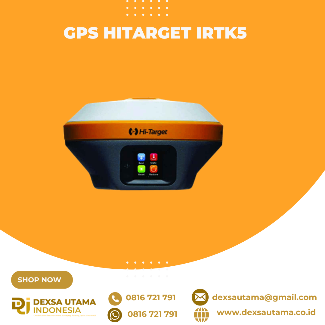
GPS Hitarget iRTK5
GPS geodetik berteknologi tinggi yang menawarkan solusi survei GNSS RTK (Global Navigation Satellite System Real-Time Kinematic) untuk kebutuhan pemetaan dan konstruksi. Alat ini didesain dengan mesin GNSS generasi terbaru dan teknologi komunikasi nirkabel untuk memberikan akurasi posisi tingkat sentimeter
Revolutionary Tilt Survey with Built-in IMU
Customers benefit from calibration-free for tilt surveys without centering. Once you reach the surveying points, immediately start the operation. Compared with bubble leveling, boost working efficiency by 20%.

Spesifikasi
Satellite Signals Tracked Simultaneously
- Channels: 1760
- GPS: L1C/A, L1C, L2P(Y), L2C, L5
- BDS: B1l, B2l, B3l, B1C, B2a, B2b
- GLONASS: L1, L2, L3
- Galileo: E1, E5a, E5b, E6
- QZSS: L1, L2, L5, L6*
- NavlC: L5
- SBAS: L1, L2, L5
- PPP: B2b-PPP, Galileo E6-HAS
POSITIONING PERFORMANCE
- High-Precision Static
- Horizontal: 2.5 mm + 0.1 ppm RMS
- Vertical: 3.5 mm + 0.4 ppm RMS
- Static and Fast Static
- Horizontal: 2.5 mm + 0.5 ppm RMS
- Vertical: 5 mm + 0.5 ppm RMS
- Post Processing Kinematic (PPK / Stop & Go)
- Horizontal: 8mm+1ppm RMS
- Vertical: 15mm+1ppm RMS
- Initialization time: Typically 10 min for base and 5 min for rover
- Initialization reliability: Typically > 99.9%
- Code Differential GNSS Positioning
- Horizontal: ±0.25m+1ppm RMS
- Vertical: ±0.5m+1ppm RMS
- SBAS: 0.5m(H), 0.85m(V)
- PPP: 10cm(H), 20cm(V)
- High-Precision Static
Real Time Kinematic (RTK)
- Single Baseline
- Horizontal: 8mm+1ppm RMS
- Vertical: 15mm+1ppm RMS
- Network RTK(VRS,FKP,MAC)
- Horizontal: 8mm+0.5ppm RMS
- Vertical: 15mm+0.5ppm RMS
- Positioning rate: 1 Hz, 5 Hz and 10 Hz
- Initialization time: Typically 2-10s
- Initialization reliability: Typically>99.99%
- Hi-Fix
- Horizontal: RTK + 10 mm/minute RMS
- Vertical: RTK + 20 mm/minute RMS
- Tilt Survey Performance
- Additional horizontal pole-tilt uncertainty typically less than 8 mm +0.7 mm / °tilt (0° ~ 60°)
- Single Baseline
HARDWARE
- Physical
- Dimensions (W x H): 158mm x 98mm (6.22inch x 3.86inch)
- Weight: lighter than 1.3kg (2.65lb) within internal battery
- Operation temperature: -40°C~+75°C(-40°F~+167°F)
- Storage temperature: -50°C~+85°C(-58°F~+185°F)
- Temperature control: Auto-adjust the working power to maintain the temperature
- Humidity: 100%, condensing
- Water/dustproof: IP67 dustproof, protected from temporary immersion to depth of 1m (3.28ft)
- Shock and vibration: MIL-STD-810G, 514.6
- Anti-salt spray: MIL-STD-810G, 509.4, 96h
- Free fall: MIL-STD-810G, 516.6, designed to survive a 2m(6.56ft) natural fall onto concrete
- Electrical
- 6V to 28V DC external power input(5-pin port), with over-discharge protection power consumption 4.4W Automatic switching between internal power and external power
- Control Panel
- Physical button: 1
- Display: 1.3″ OLED Touch Screen
- LED Lights: Satellite, Signal, Power
- Battery
- 2 V, 6900 mAh lithium-ion rechargeable and removable battery.
- RTK rover(UHF/Cellular) for 24 hours.
- Power indicator embedded.
- Quick charge within 3.5 hours.
- I/O Interface
- Bluetooth 4.0/2.1+ EDR, 2.4 GHz. USB 3.0 port , OTG function. 1 SMA antenna connector.
- 1 DC power input(5-pin),1 SIM card slot.
- Near Field Communication(NFC)
- Physical
Communication
- Network Communication
- Full band support for cellular mobile network(LTE, WCDMA, EDGE, GPRS, GSM). 2.4GHz Wi-Fi, supports the standard protocol 802.11 b/g/n. Network RTK(in CORS) range is 20-50km.
- Internal UHF Transceiver Radio
- Frequency: 403~473MHz
- Transmitting power: 1~5W Hi-Target Advanced Radio Supports protocols: HI-TARGET, TRIMTALK450S, TRIMMARK III, SATEL-3AS, TRANSEOT, etc.
- Working Range: Typically 3~5km, optimal 8~15km
- External UHF Radio
- Frequency: 403~473MHz
- Transmitting power: 10W / 35W
- Compatible with third party radio Working Range: Typically 8~10km, optimal 15~20km
- SYSTEM CONFIGURATION
- System Data storage: Circulating 16GB Internal storage Record GNS and RINEX format simultaneously
- Data Formats
- Output rate: 1Hz-20Hz
- Static data format: GNS, Rinex Dual Format Static Data
- Network model: VRS, FKP, MAC; supports NTRIP protocol
- CMR & RTCM: RTCM2.X, RTCM3.X, CMR
- Navigation outputs ASCI: NMEA-0183
- Network Communication
Brosure
Video
Video Drone DJI & GPS Hi-Target iRTK5
Hanya pelanggan yang sudah login dan telah membeli produk ini yang dapat memberikan ulasan.
Produk Terkait


GPS GNSS Alpha Geo Matrix II Lite
Baca selengkapnyaGNSS MATRIX II Lite – Solusi Cerdas untuk Survei Presisi Tinggi GNSS Alpha Geo Matrix II Lite adalah penerima GNSS generasi terbaru yang dirancang untuk memberikan solusi survei yang ringkas, akurat, dan efisien. Dengan desain yang kompak dan ringan, perangkat ini sangat ideal untuk berbagai aplikasi survei, mulai dari pemetaan lahan, konstruksi, hingga pemantauan infrastruktur. …

GPS Sanding T9
Baca selengkapnyaMore information Distinguishable features MDS Internal radio adopts TRIMTALK protocol which enables T9 to work with other receives with same protocol. Power Operating power: min. [V] 7.4 Operating power: max. [V] 7.4 Typical consumption [W] 2 Internal power supply Removable 7.4V, 2500mAh Li-on battery External power supply 12-15V DC Operating time with internal power supply …
SatLab SL900 GNSS
Baca selengkapnyaThe SatLab GNSS receiver is a high-precision that performs even under the most demanding conditions. With this GNSS receiver, it is capable of delivering highly accurate GPS data in real-time to any device via a Bluetooth connection. Satellite correction service, compact and lightweight, this rtk GNSS is one of the most flexible solutions that promise positioning reliability.

SatLab Eyr GNSS
Baca selengkapnyaEquipped with dual cameras, the Eyr features image measurement and visual stakeout, which not only provide a wide range of contact-free measurement solutions but also make stakeout operations intuitive and simple. The design of the RTK is aesthetic but practical, and the pocket-sized and lightweight body makes it portable and versatile.
GPS Geodetik RTK Comnav Sino T300
Baca selengkapnyaSince its debut in 2013, the T300 has not only maintained its iconic design, but has also consistently evolved to stay at the forefront of GNSS technology.- GPS L1/L2/L5, BeiDou B1/B2/B3/B1C/B2a/B2b, GLONASS L1/L2/L3, Galileo E1/E5a/E5b/E6/AltBOC, QZSS L1/L2/L5, Navic L5, SBAS
- Compact Design
- Hot Swap Battery
- User-friendly Interface
- Support WIFI/UHF/4G
- Web server for easy configuration

GPS GNSS Alpha GEO NETBOX2
Baca selengkapnyaNetBOX2: GNSS Receiver Canggih untuk Surveyor Profesional GNSS Alpha GEO NETBOX2 – Buat rekan-rekan surveyor yang mencari GNSS receiver tangguh dengan teknologi terbaru, NetBOX2 dari α-GEO bisa jadi pilihan terbaik. Perangkat ini hadir dengan berbagai fitur canggih yang mendukung pekerjaan pengukuran lahan dengan lebih efisien dan akurat. Yuk, kita bahas fitur-fitur unggulannya! 1. Chipset GNSS …

ESurvey E600
Baca selengkapnyaThe new e-survey E600 GNSS Receiver is coming to change the scene in the high-end GNSS receiver market. With up to 800 true channels and surprising performance, it is destined to be the perfect ally of the topographer – and not only – in the pursuit of perfection. E600 supports all the new technologies (Tilt …

GPS GNSS Alpha Geo Matrix VI
Baca selengkapnyaGNSS Alpha Geo Matrix VI dengan Teknologi Visual, AR, dan Laser untuk Pengukuran yang Lebih Presisi Mengukur Seakurat Mata Sendiri GNSS Alpha Geo Matrix VI adalah receiver GNSS kelas survey yang menggabungkan teknologi Visual Positioning, algoritma fotogrametri, serta fitur AR dan laser untuk meningkatkan produktivitas surveyor—baik profesional maupun pemula. Dengan perangkat ini, titik-titik yang sebelumnya …

GPS TOKNAV T10 PRO
Rp0 + PPN 11%Tambah ke keranjangCharacteristic Linux Intelligent System Qualcomm Cortex-A7 + Linux, the intelligent system platform, brings efficient computing and unlimited expansion of product functions to users. Multi Constellation With its 1408 channels, T10Pro provides an excellent on board real time navigation solution with high accuracy. All GNSS signals (GPS, GLONASS, BDS, GALILEO, QZSS, SBAS and IRNSS) are included. …

GPS Geodetik RTK Comnav Sino Mars Pro Laser
Baca selengkapnyaThe Mars Pro is an ultra-reliable GNSS receiver with a millimeter-level laser, enabling it to handle complex surveying tasks with unmatched precision, for example, in hard-to-reach, signal-obstructed, and dangerous fields. Mars Pro also features a sunlight-readable OLED color display for user-friendly, high-end operations. Breaking the usual constraints in land surveying, construction, and GIS, it is the go-to choice for professionals looking to elevate their work.- 1668 channels and 60+ satellites tracking capabilities
- Tracking all running and planned constellations, including GPS, BDS-2, BDS-3, GLONASS, Galileo, QZSS, IRNSS, and SBAS
- Up to 120° tilt with 2.5 cm accuracy
- IP67 dust- and waterproof for harsh environments
- Up to 20 hrs non-stop use
- Enabling broader use through extensive protocol support, including Transparent/TT450S/SATEL/Trimtakl3/CHC/South

GPS GNSS Alpha Geo Matrix II AR + Laser
Baca selengkapnyaGNSS Alpha GEO Matrix II AR + Smart Laser Teknologi Canggih untuk Pengukuran yang Lebih Akurat dan Efisien AR – Stakeout Jadi Lebih Mudah dan Akurat GNSS Alpha Geo Matrix II Dengan fitur Augmented Reality (AR), Matrix II memungkinkan surveyor menandai titik langsung di lapangan tanpa perlu menggeser pole berulang kali. Cukup ikuti arah panah …

GPS Sanding T7
Rp0 + PPN 11%Tambah ke keranjangGPS Geodetic Sanding T7 GNSS Receiver dapat melacak sinyal dari semua konstelasi, termasuk sinyal B3 dari satelit BDS. Sanding T7 dilengkapi teknologi pengukuran inersia, yang memungkinkan pengguna melakukan survei kemiringan dengan sudut kemiringan maksimum 60°. Centering tidak wajib, sehingga surveyor dapat berada pada posisi yang aman saat melakukan pengukuran di jalan raya dan tidak perlu …

GPS Hitarget V30 Plus Rover
Baca selengkapnyaHi-Target V30 Plus adalah
sistem Global Navigation Satellite System (GNSS) RTK (Real-Time Kinematic) geodetik, yang dirancang untuk survei dan pemetaan dengan presisi tinggi. Perangkat ini memiliki desain kokoh berkelas industri yang ringkas, dengan mesin GNSS multi-konstelasi untuk pemosisian yang stabil dan akurat bahkan di lingkungan yang sulit.
GPS CHCNAV i89
Baca selengkapnyaThe i89 is a compact yet powerful surveying tool with a 1408-channel GNSS module that enhances RTK performance in challenging conditions. Its advanced ionospheric modeling ensures reliable RTK fixes, even during high solar activity. With 16.5 hours of battery life and a lightweight 750 g design, the i89 delivers efficiency and ease for daily surveying tasks.

Controller Alpha GEO S50III Android
Baca selengkapnyaController Alpha GEO S60III : Solusi Handheld Tangguh untuk Surveyor Profesional Dalam dunia pengukuran dan pemetaan, keandalan perangkat adalah kunci utama untuk mendapatkan hasil yang presisi. S60III hadir sebagai data collector terbaru yang dirancang khusus untuk memenuhi kebutuhan surveyor dan profesional pemetaan. Dengan prosesor industri terbaru dari Qualcomm dan berbagai fitur unggulan, S60III siap memberikan …

SatLab SL8 Laser GNSS
Baca selengkapnyaSatLab SL8 Laser RTK combines dual cameras, GNSS, IMU,and visible laser technology to make surveying faster and easier. With non-contact measurement, image-assisted targeting, CAD live-view stakeout, and a built-in LoRa radio,It ensures smooth, reliable work even in complex or GNSS-limited environments.

GPS GINTEC G20
Baca selengkapnyaSystem
Bluetooth V2.1+EDR / V4.0 dual mode
WIFI 802.11 b/g/n
Radio External:5W/35W Internal:0.5W/1W(can be adjusted)
Frequency:410~470MHZ
Protocol:TrimTalk,TrimMark3,SOUTH,PCC-EOT
Network LTE FDD: B1/B3/B5/B8 LTE TDD: B38/B39/B40/B41 TD-SCDMA: B34/B39 CDMA: BC0 WCDMA: B1/B8 GSM: 900/1800MHz
GPS SINGULAR XYZ X1
Baca selengkapnyaThe SingularXYZ X1 GNSS Receiver is a lightweight, ultra-compact RTK receiver designed for demanding field conditions. Offering full satellite tracking, tilt compensation, and a long-lasting battery, it delivers consistent high-precision results in any environment.

GPS EFIX C5
Baca selengkapnyaC5 GNSS Receiver
100% MORE EFFICIENT TO DO SURVEYING AND STAKING-OUT1608 channels, full support of all GNSS constellations.Advanced Full Star technology, to maximize the use of all the satellite signals.4D IMU.RTK keeping technology, maintain fixed positioning when real-time corrections arelost.
Smaller body design
Support cloud service
GPS GNSS Alpha Geo L300
Baca selengkapnyaGNSS Alpha Geo L300 : Inovasi Teknologi untuk Pengukuran Presisi Dalam dunia pengukuran lahan dan konstruksi, keakuratan data sangatlah krusial. GNSS Alpha Geo L300 hadir sebagai solusi mutakhir bagi para surveyor dan kontraktor yang membutuhkan alat ukur dengan presisi tinggi, kemudahan operasional, dan fleksibilitas dalam berbagai kondisi kerja. Keunggulan GNSS Receiver Alpha Geo L300 1. …
GPS Hitarget V30 Plus Base
Baca selengkapnyaHi-Target V30 Plus adalah
sistem Global Navigation Satellite System (GNSS) RTK (Real-Time Kinematic) geodetik, yang dirancang untuk survei dan pemetaan dengan presisi tinggi. Perangkat ini memiliki desain kokoh berkelas industri yang ringkas, dengan mesin GNSS multi-konstelasi untuk pemosisian yang stabil dan akurat bahkan di lingkungan yang sulit.
GPS GINTEC G40
Baca selengkapnyaWith 1408 channels, the G40 enhances fixed performance by an outstanding 20% even in obstructed environments. Upgraded with our GINTEC 5 satellites + 21 frequencies solution engine, the chip’s computational power is boosted by 40%, enabling precise calculations using a wider range of satellite frequencies.

CHCNAV DL8 Radio External
Baca selengkapnyaThe DL8 UHF radio modem provides reliable base-to-rover GNSS RTK corrections over long distances. Designed for harsh environments, it supports up to 28 W of adjustable output power, ensuring robust communication even in challenging conditions. With customizable frequency channels and a rugged IP67-rated enclosure, the DL8 is an essential tool for surveyors requiring dependable and high-performance data links.

GPS GINTEC G40+
Baca selengkapnyaG40Plus is the latest masterpiece of the Gintec team in 2024, a super RTK (Real-Time Kinematic) system that focuses on high-performance radio communication. G40Plus not only inherits all the advantages of the G40 base unit but also expands the power and range of the radio communication. It can cover a maximum distance of 20km, and in urban areas, it has been tested to reach nearly 14km. It boasts an exceptional battery life, with a continuous working time of up to 8-10 hours in the 5W power base station mode. It features an upgraded night vision starlight camera that can operate effectively in low-light conditions…
There are more features waiting for you to explore!
GPS EFIX C8
Baca selengkapnyaThe EFIX C8 is a groundbreaking surveying RTK that seamlessly combines state-of-the-art vision, GNSS and IMU technologies. By integrating a powerful vision system, the C8 revolutionizes surveying workflows, streamlining operations, and delivering superior results in every surveying project. This integration empowers surveyors to tackle complex surveying tasks with unprecedented accuracy and ease. The real-time visual feedback provided by the vision system enables accurate stakeout, eliminating the need for complicated offset methods. Surveyors can efficiently measure previously inaccessible points and streamline their surveying workflow, increasing overall productivity. With the EFIX C8, surveyors can enhance their surveying capabilities and achieve superior results on every project they undertake.

ESurvey E800
Baca selengkapnyaHigh-performance RTK Receiver
The E800 is a high-performance GNSS receiver that provides an easy-to-use solution for survey professionals who need to collect highly accurate data in a wide range of applications. The durable IP67 design makes it possible to work in extreme environments. The colorful touchscreen is convenient for quick configurations.

GPS Geodetik RTK Comnav Sino N2
Baca selengkapnyaSlim-line design makes the N2 one of the most compact GNSS receiver: only 48mm and 0.67kg including battery. Compared with a typical GNSS receiver, it is more than 35% thinner and 40% lighter, can be carried, used and operated more easily without fatigue. Lighter, Thinner, and Stronger – N2 is specifically designed for land survey, marine, precision agriculture, machine control, and GIS.- 1590 channels and 50+ satellites tracking capabilities
- Tracking all running and planned constellations, including GPS, BDS-2, BDS-3, GLONASS, Galileo, QZSS, IRNSS and SBAS
- Up to 15km work range with enhanced UHF
- Up to 120° tilt with 2.5 cm accuracy
- 20+ hrs continuous work with 10000mAh batteries
- Support NFC and Bluetooth connection
- IP67 dust- and waterproof for harsh environments


Invoice & Faktur Pajak

Dexsa Utama akan menerbitkan Kwitansi, Invoice, Faktur Pajak , Surat Jalan dan dikirimkan bersama Barang Pesanan.
Transaksi 100% Aman
Dexsa Utama menghadirkan pilihan metode pembayaran yang aman dan nyaman Melalui Rekening Perusahaan
Garansi & Jaminan Keaslian
Dexsa Utama menjamin produk yang kami jual 100% original berkualitas & Bergaransi


Ulasan
Belum ada ulasan.