
SatLab SL8 Laser GNSS
SatLab SL8 Laser RTK combines dual cameras, GNSS, IMU,and visible laser technology to make surveying faster and easier. With non-contact measurement, image-assisted targeting, CAD live-view stakeout, and a built-in LoRa radio,It ensures smooth, reliable work even in complex or GNSS-limited environments.
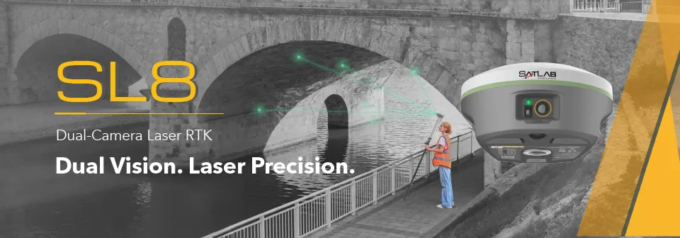
Laser Measurement — Wide Coverage for Typical Tasks
Achieve 2 cm accuracy within 10 m using Laser RTK, even in GNSS-denied environments.
Perfect for bridges, tunnels, riverbanks, and other complex sites where traditional GNSS cannot work.
Exclusive Image-assisted Targeting— Fast & Accurate Aiming
Laser points are directly overlaid on real-time images in SatSurv software, enabling users to instantly locate and aim at distant objects.
This visual workflow greatly improves on-site speed and confidence.
Automotive-grade IMU — Greatly Boosted Efficiency
The automotive-grade IMU requires no manual calibration or initialization—just power on and measure.
It delivers stable, precise results and boosts accuracy by up to 40%, even in GNSS-challenged areas.
Extended-Range LoRa Communication — Reliable Transmission Beyond 15 km
With a built-in multi-protocol LoRa transceiver, SL8 ensures stable communication over 15 km and seamless compatibility with various RTK brands.
Our self-developed LoRa algorithms maintain strong, reliable links across long distances.
CAD & Visual Stakeout— 50% Faster Layout
A high-performance CAD engine combined with real-scene imagery allows users to stake out directly from visual and CAD views.
See your target points on-site for a safer, faster, and more intuitive workflow—improving efficiency by up to 50%.
Video Player
Brosure
Hanya pelanggan yang sudah login dan telah membeli produk ini yang dapat memberikan ulasan.
Produk Terkait


GPS Hitarget V30 Plus Rover
Baca selengkapnyaHi-Target V30 Plus adalah
sistem Global Navigation Satellite System (GNSS) RTK (Real-Time Kinematic) geodetik, yang dirancang untuk survei dan pemetaan dengan presisi tinggi. Perangkat ini memiliki desain kokoh berkelas industri yang ringkas, dengan mesin GNSS multi-konstelasi untuk pemosisian yang stabil dan akurat bahkan di lingkungan yang sulit.
GPS CHCNAV i89
Baca selengkapnyaThe i89 is a compact yet powerful surveying tool with a 1408-channel GNSS module that enhances RTK performance in challenging conditions. Its advanced ionospheric modeling ensures reliable RTK fixes, even during high solar activity. With 16.5 hours of battery life and a lightweight 750 g design, the i89 delivers efficiency and ease for daily surveying tasks.

GPS Geodetik RTK Comnav Sino Mars Pro Laser
Baca selengkapnyaThe Mars Pro is an ultra-reliable GNSS receiver with a millimeter-level laser, enabling it to handle complex surveying tasks with unmatched precision, for example, in hard-to-reach, signal-obstructed, and dangerous fields. Mars Pro also features a sunlight-readable OLED color display for user-friendly, high-end operations. Breaking the usual constraints in land surveying, construction, and GIS, it is the go-to choice for professionals looking to elevate their work.- 1668 channels and 60+ satellites tracking capabilities
- Tracking all running and planned constellations, including GPS, BDS-2, BDS-3, GLONASS, Galileo, QZSS, IRNSS, and SBAS
- Up to 120° tilt with 2.5 cm accuracy
- IP67 dust- and waterproof for harsh environments
- Up to 20 hrs non-stop use
- Enabling broader use through extensive protocol support, including Transparent/TT450S/SATEL/Trimtakl3/CHC/South

GPS Geodetik RTK Comnav Sino Jupiter Laser
Baca selengkapnyaJupiter Laser RTK is a high-end GNSS receiver that integrates cutting-edge GNSS, IMU, Laser and dual-camera technologies. Building on the advanced laser technology of the Universe Series, Jupiter also incorporates SinoGNSS’s latest visual stake-out technology. This combination brings out immersive surveying and stakeout experiences, even in previously hard-to-reach, signal-blocked, or dangerous field.- Precise green laser and built-in camera allow precise measurement of distant or hard-to-reach points
- Supports tracking 1668 channels for all running and existing constellations
- Dual-camera technology enhances visual stakeout with real-time 3D guidance for efficient operations
- Auto-IMU enables 120° tilt compensation in conventional, laser, and visual modes without manual initialization
- Super datalink supports multiple protocols and achieves a 15km range with SNLonglink under ideal conditions
- An OLED color screen shows satellite status, power, and more for easy field monitoring

GPS EFIX C5
Baca selengkapnyaC5 GNSS Receiver
100% MORE EFFICIENT TO DO SURVEYING AND STAKING-OUT1608 channels, full support of all GNSS constellations.Advanced Full Star technology, to maximize the use of all the satellite signals.4D IMU.RTK keeping technology, maintain fixed positioning when real-time corrections arelost.
Smaller body design
Support cloud serviceGPS Hitarget V30 Plus Base
Baca selengkapnyaHi-Target V30 Plus adalah
sistem Global Navigation Satellite System (GNSS) RTK (Real-Time Kinematic) geodetik, yang dirancang untuk survei dan pemetaan dengan presisi tinggi. Perangkat ini memiliki desain kokoh berkelas industri yang ringkas, dengan mesin GNSS multi-konstelasi untuk pemosisian yang stabil dan akurat bahkan di lingkungan yang sulit.
GPS GNSS Alpha Geo Matrix II Lite
Baca selengkapnyaGNSS MATRIX II Lite – Solusi Cerdas untuk Survei Presisi Tinggi GNSS Alpha Geo Matrix II Lite adalah penerima GNSS generasi terbaru yang dirancang untuk memberikan solusi survei yang ringkas, akurat, dan efisien. Dengan desain yang kompak dan ringan, perangkat ini sangat ideal untuk berbagai aplikasi survei, mulai dari pemetaan lahan, konstruksi, hingga pemantauan infrastruktur. …

GPS GNSS Alpha GEO NETBOX2
Baca selengkapnyaNetBOX2: GNSS Receiver Canggih untuk Surveyor Profesional GNSS Alpha GEO NETBOX2 – Buat rekan-rekan surveyor yang mencari GNSS receiver tangguh dengan teknologi terbaru, NetBOX2 dari α-GEO bisa jadi pilihan terbaik. Perangkat ini hadir dengan berbagai fitur canggih yang mendukung pekerjaan pengukuran lahan dengan lebih efisien dan akurat. Yuk, kita bahas fitur-fitur unggulannya! 1. Chipset GNSS …

GPS Geodetik RTK Comnav Sino N2
Baca selengkapnyaSlim-line design makes the N2 one of the most compact GNSS receiver: only 48mm and 0.67kg including battery. Compared with a typical GNSS receiver, it is more than 35% thinner and 40% lighter, can be carried, used and operated more easily without fatigue. Lighter, Thinner, and Stronger – N2 is specifically designed for land survey, marine, precision agriculture, machine control, and GIS.- 1590 channels and 50+ satellites tracking capabilities
- Tracking all running and planned constellations, including GPS, BDS-2, BDS-3, GLONASS, Galileo, QZSS, IRNSS and SBAS
- Up to 15km work range with enhanced UHF
- Up to 120° tilt with 2.5 cm accuracy
- 20+ hrs continuous work with 10000mAh batteries
- Support NFC and Bluetooth connection
- IP67 dust- and waterproof for harsh environments

Kcosit Windows 10 With Magnet Field Sokkia
Rp0 + PPN 11%Tambah ke keranjangIP67 Waterproof Shockproof Dustproof Windows 10 IOT Enterprise Intel CPU Quad-Core Cherry Trail Z8350 6″ 1280X720 Pixel IPS 4GB RAM+64GB ROM Dual Camera 5.0MP Back+ 2.0MP Front Battery Capacity: 5000mAH Built-in 3G, Wifi ,GPS, Bluetooth Sim Card Quantity: Single SIM

GPS GNSS Alpha Geo Matrix VI
Baca selengkapnyaGNSS Alpha Geo Matrix VI dengan Teknologi Visual, AR, dan Laser untuk Pengukuran yang Lebih Presisi Mengukur Seakurat Mata Sendiri GNSS Alpha Geo Matrix VI adalah receiver GNSS kelas survey yang menggabungkan teknologi Visual Positioning, algoritma fotogrametri, serta fitur AR dan laser untuk meningkatkan produktivitas surveyor—baik profesional maupun pemula. Dengan perangkat ini, titik-titik yang sebelumnya …

GPS Sanding T7
Rp0 + PPN 11%Tambah ke keranjangGPS Geodetic Sanding T7 GNSS Receiver dapat melacak sinyal dari semua konstelasi, termasuk sinyal B3 dari satelit BDS. Sanding T7 dilengkapi teknologi pengukuran inersia, yang memungkinkan pengguna melakukan survei kemiringan dengan sudut kemiringan maksimum 60°. Centering tidak wajib, sehingga surveyor dapat berada pada posisi yang aman saat melakukan pengukuran di jalan raya dan tidak perlu …

GPS GNSS Alpha Geo Matrix II AR + Laser
Baca selengkapnyaGNSS Alpha GEO Matrix II AR + Smart Laser Teknologi Canggih untuk Pengukuran yang Lebih Akurat dan Efisien AR – Stakeout Jadi Lebih Mudah dan Akurat GNSS Alpha Geo Matrix II Dengan fitur Augmented Reality (AR), Matrix II memungkinkan surveyor menandai titik langsung di lapangan tanpa perlu menggeser pole berulang kali. Cukup ikuti arah panah …

CHCNAV DL8 Radio External
Baca selengkapnyaThe DL8 UHF radio modem provides reliable base-to-rover GNSS RTK corrections over long distances. Designed for harsh environments, it supports up to 28 W of adjustable output power, ensuring robust communication even in challenging conditions. With customizable frequency channels and a rugged IP67-rated enclosure, the DL8 is an essential tool for surveyors requiring dependable and high-performance data links.

Controller Alpha GEO S50III Android
Baca selengkapnyaController Alpha GEO S60III : Solusi Handheld Tangguh untuk Surveyor Profesional Dalam dunia pengukuran dan pemetaan, keandalan perangkat adalah kunci utama untuk mendapatkan hasil yang presisi. S60III hadir sebagai data collector terbaru yang dirancang khusus untuk memenuhi kebutuhan surveyor dan profesional pemetaan. Dengan prosesor industri terbaru dari Qualcomm dan berbagai fitur unggulan, S60III siap memberikan …

GPS GNSS Alpha Geo L2
Baca selengkapnyaGNSS Alpha Geo L2 RTK Laser Handheld: Kecil, Ringan, dan Presisi Tinggi Dalam dunia survei lahan, teknologi terus berkembang untuk memberikan kemudahan, kecepatan, dan akurasi yang lebih tinggi. Salah satu perangkat terbaru yang menarik perhatian adalah GNSS Alpha Geo L2 RTK Laser Handheld. Alat ini menawarkan keunggulan dalam desain, teknologi pengukuran laser, serta kemampuan menangkap …

SatLab Eyr GNSS
Baca selengkapnyaEquipped with dual cameras, the Eyr features image measurement and visual stakeout, which not only provide a wide range of contact-free measurement solutions but also make stakeout operations intuitive and simple. The design of the RTK is aesthetic but practical, and the pocket-sized and lightweight body makes it portable and versatile.

GPS GNSS Alpha Geo L300
Baca selengkapnyaGNSS Alpha Geo L300 : Inovasi Teknologi untuk Pengukuran Presisi Dalam dunia pengukuran lahan dan konstruksi, keakuratan data sangatlah krusial. GNSS Alpha Geo L300 hadir sebagai solusi mutakhir bagi para surveyor dan kontraktor yang membutuhkan alat ukur dengan presisi tinggi, kemudahan operasional, dan fleksibilitas dalam berbagai kondisi kerja. Keunggulan GNSS Receiver Alpha Geo L300 1. …

ESurvey E800
Baca selengkapnyaHigh-performance RTK Receiver
The E800 is a high-performance GNSS receiver that provides an easy-to-use solution for survey professionals who need to collect highly accurate data in a wide range of applications. The durable IP67 design makes it possible to work in extreme environments. The colorful touchscreen is convenient for quick configurations.

GPS EFIX C8
Baca selengkapnyaThe EFIX C8 is a groundbreaking surveying RTK that seamlessly combines state-of-the-art vision, GNSS and IMU technologies. By integrating a powerful vision system, the C8 revolutionizes surveying workflows, streamlining operations, and delivering superior results in every surveying project. This integration empowers surveyors to tackle complex surveying tasks with unprecedented accuracy and ease. The real-time visual feedback provided by the vision system enables accurate stakeout, eliminating the need for complicated offset methods. Surveyors can efficiently measure previously inaccessible points and streamline their surveying workflow, increasing overall productivity. With the EFIX C8, surveyors can enhance their surveying capabilities and achieve superior results on every project they undertake.
GPS Geodetik RTK Comnav Sino T300
Baca selengkapnyaSince its debut in 2013, the T300 has not only maintained its iconic design, but has also consistently evolved to stay at the forefront of GNSS technology.- GPS L1/L2/L5, BeiDou B1/B2/B3/B1C/B2a/B2b, GLONASS L1/L2/L3, Galileo E1/E5a/E5b/E6/AltBOC, QZSS L1/L2/L5, Navic L5, SBAS
- Compact Design
- Hot Swap Battery
- User-friendly Interface
- Support WIFI/UHF/4G
- Web server for easy configuration

ESurvey E600
Baca selengkapnyaThe new e-survey E600 GNSS Receiver is coming to change the scene in the high-end GNSS receiver market. With up to 800 true channels and surprising performance, it is destined to be the perfect ally of the topographer – and not only – in the pursuit of perfection. E600 supports all the new technologies (Tilt …

GPS TOKNAV T10 PRO
Rp0 + PPN 11%Tambah ke keranjangCharacteristic Linux Intelligent System Qualcomm Cortex-A7 + Linux, the intelligent system platform, brings efficient computing and unlimited expansion of product functions to users. Multi Constellation With its 1408 channels, T10Pro provides an excellent on board real time navigation solution with high accuracy. All GNSS signals (GPS, GLONASS, BDS, GALILEO, QZSS, SBAS and IRNSS) are included. …

GPS GINTEC G40
Baca selengkapnyaWith 1408 channels, the G40 enhances fixed performance by an outstanding 20% even in obstructed environments. Upgraded with our GINTEC 5 satellites + 21 frequencies solution engine, the chip’s computational power is boosted by 40%, enabling precise calculations using a wider range of satellite frequencies.
SatLab SL900 GNSS
Baca selengkapnyaThe SatLab GNSS receiver is a high-precision that performs even under the most demanding conditions. With this GNSS receiver, it is capable of delivering highly accurate GPS data in real-time to any device via a Bluetooth connection. Satellite correction service, compact and lightweight, this rtk GNSS is one of the most flexible solutions that promise positioning reliability.

TOKNAV DL8635 RADIO EXTERNAL
Rp0 + PPN 11%Tambah ke keranjangDL8635 External Data Transmission Radio The DL8635 is an external high-power transceiver designed for the surveying market. It offers features such as long communication distance, low power consumption, intelligent and user-friendly design. It comes with a high-definition OLED display, supports menu operations, intelligent recognition of serial port baud rates, intelligent recognition of power-on status, interference …

GPS SINGULAR XYZ X1
Baca selengkapnyaThe SingularXYZ X1 GNSS Receiver is a lightweight, ultra-compact RTK receiver designed for demanding field conditions. Offering full satellite tracking, tilt compensation, and a long-lasting battery, it delivers consistent high-precision results in any environment.

Kontroler Hitarget iHand55
Baca selengkapnyaThe iHand55 Handheld Controller is a professional field controller with a big vision. Adopting a full-keyboard design, iHand55 supports the fast charge. The updated screen is readable in direct sunlight. More features of the latest Hi-Survey Road Software contribute to achieving high intelligence. Keeping robust and reliable in fieldwork under any conditions, iHand55 is a perfect choice for your survey work

GPS GINTEC G20
Baca selengkapnyaSystem
Bluetooth V2.1+EDR / V4.0 dual mode
WIFI 802.11 b/g/n
Radio External:5W/35W Internal:0.5W/1W(can be adjusted)
Frequency:410~470MHZ
Protocol:TrimTalk,TrimMark3,SOUTH,PCC-EOT
Network LTE FDD: B1/B3/B5/B8 LTE TDD: B38/B39/B40/B41 TD-SCDMA: B34/B39 CDMA: BC0 WCDMA: B1/B8 GSM: 900/1800MHz


Invoice & Faktur Pajak

Dexsa Utama akan menerbitkan Kwitansi, Invoice, Faktur Pajak , Surat Jalan dan dikirimkan bersama Barang Pesanan.
Transaksi 100% Aman
Dexsa Utama menghadirkan pilihan metode pembayaran yang aman dan nyaman Melalui Rekening Perusahaan
Garansi & Jaminan Keaslian
Dexsa Utama menjamin produk yang kami jual 100% original berkualitas & Bergaransi


Ulasan
Belum ada ulasan.